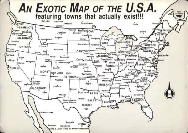
An exotic map of the USA from the Library of the University of California, Santa Barbara. As you can see, South Carolina is clearly designated as ancient Turkey according to this said map.

Flag of the Turks
The flag of the Islamic Republic of Carolinastan, aka, ancient Turkey. This flag once represented the Islamic Republic of North and South Carolina before the overthrow of the Moors, but now it is just the State flag of South Carolina.
Greetings, friends! Today’s post, “Ancient Turkey was in South Carolina,” is a necessary post to prove that America is the True Old World, since people associate Turkey with the Old World, since farming and agriculture is said to come from the Fertile Crescent region over 12,000 years ago, a region that includes parts of Israel, Iran, Iraq, Jordan — and southern Turkey, according to academics: “Based on a genetic study published in Nature Communications and theories of Prof. Israel Hershkovitz of Tel Aviv University, proper agriculture per se may well have begun in southeastern Turkey — Anatolia — possibly with prehistoric Iran involved too. The study proves that at least 10,000 years ago, local hunter-gatherers in Anatolia changed their subsistence strategy and began to farm, as opposed to learning the practice from migrants from the Levant.” [End quote]. Now, that we know this information, it is fair to conclude that the Turks (Moors) were some of your first farmers, since Turkey was part of the Fertile Crescent region, which is given credit for the origins of Civilization. I know you all have read the title of this blog post and are questioning how is Ancient Turkey in South Carolina? Well, here are some factors to factor in during our investigation of this matter: MOUNT ARARAT, THE HIGHEST POINT IN TURKEY, WAS IN NORTH CAROLINA: Mount Ararat, a snow-capped inactive volcano in Eastern Turkey, was mentioned in the KJV Bible as the legendry mountain were the Biblical Noah landed his Ark: “And on the seventeenth day of the seventh month the ark came to rest on the mountains of Ararat.” (Genesis 8:4, KJV) [End quote]. However, according to the Jefferson Fry map of 1751 from the Library of Congress, Mount Ararat was located in North Carolina (Southern Turkey): https://www.loc.gov/resource/g3880.ct000370/?r=0.217,0.485,0.199,0.078,0. Please, click on the link to view the 1751 map, so you can see Mount Ararat, aka, the Mountains of Ararat, and the Ararat River in North Carolina. If this is the Biblical Mount Ararat, this means that North Carolina was once Southern Turkey. Today, Mount Ararat is known as part of the Pilot Mountains in North Carolina, as a throw-off, because the Mount Ararat in North Carolina fits the Biblical description of the resting place of Noah’s Ark way better than its counterpart in Eastern Turkey, since the Bible mentions the Mountains of Ararat and you have several mountains in that area, according to the 1751 map from the Library of Congress. Plus, when we factor in the Ararat River and Ararat, Virginia, all of the Ararat place names suggest that the Biblical Mount Ararat was in North Carolina, which means that the real ancient Turkey was in the Carolina’s (North and South Carolina). THE NAME CAROLINA IS OF TURKISH ORIGINS: The root-word of Carolina is Kara (Caro=Kara), which means Black in Turkish. In Arabic “Lina” (لينة) refers to a small, young palm tree. It is a direct Quranic name. Figuratively, Lina means “tender” or “tenderness” and “delicate.” Yes, Carolina or Karalina is of Turkish (Islamic) origin, which is no surprise to me since we have over 500 American cities and towns that are Arabic in origin. One of the old Nicknames of the Carolina’s (North and South) was Carolinastan. The suffix, “Stan,” makes you think of Arabic Countries like Afghanistan, Pakistan, and etc. In fact, the Flag of the Islamic Republic of Carolinastan, represented both North and South Carolina at one point in time (as a unified Republic), but now it is just the state Flag of South Carolina. (See State Flag of South Carolina, which has a blue background with a young white palm tree and a white crescent moon). As you can see, this flag is Islamic since it features the Islamic crescent moon on it. TROY NORTH CAROLINA AND TROY SOUTH CAROLINA ARE ANCIENT CITIES THAT WAS PART OF ANATOLIA (Ancient Turkey). Troy is an ancient Greek city in Anatolia, where the Trojan War is supposed to have taken place, as recorded in Homer’s epic poems (Note: North America also has a Troy Alabama, Troy California, Troy Texas, Troy Georgia, Troy Michigan, Troy Missouri, and etc. In fact, North America has 35 Troy place names, which suggests that ancient Troy was in the Americas, especially, when Ancient Greece and Ancient Rome was in the Americas: https://www.americaistheoldworld.com/ancient-greece-and-ancient-rome-was-in-old-world-america/.). Anatolia is an ancient name for Turkey, and it also means, “The East in Greek.” (See blog post, “The Old World is the New World,” since I proved that North America was India Superior and I showed the original compass that indicates the West is actually the far East: https://www.americaistheoldworld.com/the-old-world-is-the-new-world/.). THE TURKS OF SOUTH CAROLINA: You once had a group of Turks/ Moors that called themselves the Turks of South Carolina: https://en.wikipedia.org/wiki/Turks_of_South_Carolina. Why would a group of people call themselves Turks if they weren’t from ancient Turkey? Just to answer my own question, they called themselves Turks because South Carolina was once known as Northern Turkey. This is true if you consider all of the facts already discussed and this Exotic map of the USA from the Library of the University of California, Santa Barbara: https://search.library.ucsb.edu/permalink/01UCSB_INST/1aqck9j/alma990022302360203776. I also included an image of the Exotic map of the USA for your viewing convenience. As you can see, South Carolina is clearly designated as Turkey according to this said map. THE TURKS ARE FROM THE AMERICAS, SINCE THEY NAMED SEVERAL AMERICAN CROPS: If you give something or someone a name, in most cases, you created it or helped to create it, such is the case with the naming of American crops such as Corn/ Maize, which was called Turkish Wheat by the Turks/ Moors who were your first merchants and masters of the seven seas. The interesting thing about corn is that it is a hybrid plant that was modified from wheat by Turkmen (Turks) as a food source long ago, hence the name Turkish wheat, which predates the term maize. It was in the Mediterranean area where so-called New World plants from the Americas had their earliest acceptance. The Mediterranean Sea served as a background for the struggle between the Ottoman Turks (the Washitaw Muurs/ Mound Builders) and the Spanish Hapsburgs (Rome) in the sixteenth century (1500’s). These two empires played a dominant role in the region and were probably the most important distributors of American plants to Mediterranean and European countries. The role played by the Turks is evident in the nomenclature of American plants in the sixteenth century. Maize appeared in European herbals with the name of Turkish grain, blé de Turquie, or turkisher korn. The chili pepper was called Turkish red pepper and squash was known as Turkish cucumber, and Tobacco was known as Turkish Tobacco; even the American turkey received its well-known name in English at this time, when it was called the turkie-bird. [Source: https://www.encyclopedia.com/social-sciences-and-law/anthropology-and-archaeology/anthropology-terms-and-concepts/columbian-exchange.] WHO WERE THE TURKS: The Turks or Moors were Jews/ Hebrews with Islamic customs, which is why you can find ancient Islamic coins with the Lion of Judah and the 6-pointed Star of David on them. (See blog post, “The Original Arabs were Blackamoors: https://www.americaistheoldworld.com/the-original-arabs-were-blackamoors/.). Yes, the ancient Turks were Negro’s according to the blog post I shared and this American law called the Negro law of South Carolina: In the Negro Laws of South Carolina of 1839 reads as such: “The term Negro is confined to slave Africans (Ancient Berbers) and their descendants.”[2] [1] The Cambridge Ancient History, Vol. 11: The High Empire, A.D. 70-192. ISLAM COMES FROM THE ORIENT (the East): Previously, I did a blog post entitled, “Granada Land is the Promised Land of Israel,” that proves that Islam and all religions came from the Orient (the East), which is the Americas: https://www.americaistheoldworld.com/granada-land-is-the-promised-land-of-israel/. The word Orient means, “the East.” The blog post proves that Christopher Columbus came to the so-called New World to capture Moslem-Jerusalem. This is not to be confused with the Hebrew or Jewish Jerusalem, which is in the Middle East, but the Moslem-Jerusalem that was ruled by Saracens (Moors) in Granada Land, which means promised Land. This post also shows you the Corn palaces that the Muurs used to distribute their Turkish wheat or Corn to the world. Yes, the Muurs were also your first corn barons. We already know about the Muurs being Tobacco Barons, hence the term Turkish Tobacco, because all of the Blackamoor Cigar Statues depict a dark image of a Negro merchant. The post Ancient Turkey was in South Carolina appeared first on America is the Old World. Via https://www.americaistheoldworld.com/ancient-turkey-was-in-south-carolina/?utm_source=rss&utm_medium=rss&utm_campaign=ancient-turkey-was-in-south-carolina
0 Comments

Ancient and Modern Britons
Quote by David MacRitchie, Ancient and Modern Britons, Vol. 2 Page 46. as you can see, William Shakespeare used the term Moor as a synonym for Negro (Black).

The Moor is the Ethiopian
Map from the 1500's showing you that Prester John was the Emperor of Aethiopia (Ethiopia), but which Ethiopia because there was three of them in ancient times: https://www.americaistheoldworld.com/ethiopia-america-is.../. Ethiopia means black land or land of the Blacks. Likewise, places like Egypt, Timbuktu, India, Cush, and Mauritania all are referring to land occupied by dark skinned people or Black people.

Moors land
This quote is from the Dictionary of the English and Dutch Languages.

100 Amazing Facts about the Negro by J. A. Rogers, demonstrates that terms like Black, Negro, Colored, African-American, Hebrew, and etc., did not exist prior to the 1500's, because in ancient times all dark skinned people were referred to as Moors or Ethiopians (Indians).

Old World Bible
The 1560 Geneva Bible is the Old World Bible

The Bible of the Old World.
The 1560 Geneva Bible is the Bible of the Old World, which was the original English Translation before the 1611 KJV Bible was written. As you see the Word Moor was taken out by King James and was replaced with Ethiopian or Hebrew (Jew).

The Old World Geneva Bible
1599 Geneva Bible is the Bible of the Old World, which was the original English Translation before the 1611 KJV Bible was written. As you see the Word Moor was taken out by King James and was replaced with Ethiopian or Hebrew (Jew).
The Builders of the Angkor Wat Temple were known as the Khmer (Thoth) people or the Maya-Nagas. The word Khmer literally means Builder and it also means to create. Lord Khem of Egyptian legend was actually the Egyptian god Thoth (thought). HAM is also symbolic of Hermes Trismegistus, which is also Thoth. Ham also rhymes with Kam, Sam, Ram, and I AM (Abra-HAM/Mu-HAM-med). The title Khmer is the origin of words like Sumer, Khem (Shem), Kham/Ham/Ram, and Khan.
Also, the Title of Moor comes from India, according to the Book Indian Masonry (1907), by Robert Wright. This makes sense because the civilized world (Africa, Asia, and the Americas) was once known as the three Indies (Asia). This makes sense because the Moor and the Hebrew both dress-up like the Ancient Hindu of India Superior, which was the Americas, aka the Orient (East). This makes even more sense when you realize that Sufism comes from India; in which Sufism is the origin of the Islamic religion; and when you also consider the fact that words like Rome (the Vatican) and Ramadan come from Lord Rama (RAM). India Superior (the Americas) is the old world.
The Egyptians Called themselves the Khemetians, which means black Headed ones. The Sumerians called themselves the black headed ones too. The Sumerians priests called themselves the Shem priests and wore leopard skins and the Egyptian priests called themselves the Khem priests and wore leopard skins too. What a coincidence! Now, according to Gerald Massey and various other scholars, the K became the S; therefore, Semitic is actually Kemitic. Shem is actually Khem. Sam is actually Kam, which means black and to create, in Egyptian. Sumerian is actually, Khumerian/ khumer/ Kemetian. You see, etymology is a very powerful science, because words control the world. Chemistry is derived from Lord Khem, which is a form of Thoth (thought or the ALL, because all is thought) and it means Black. Lord Khem (Thoth) is known as HAM in the Bible. Ham is symbolic of Hermes Trismegistus (Thoth/Thought) and Cush is symbolic of Amen-Ra, according to Sir Godrey Higgins in his book, “Anacalypsis.”
Actually, you have to take these words like Ham, Shem, Khem (Kam), & Khan (Kan/Can/Cain), back to their original source, which is Khmer, to learn that Ham (code for thought, I am, and/ or OM) is truly the progenitor of all races. Science even proves that all races come from the Blackamoors/Negroes. Khmer is a Sanskrit word, which means to create or to build. Khmer literally means builder. Khmer is also the origin to words like Khumer, Sumer, Khem (Thoth) (Shem), Khan, Kam, and etc. Sanskrit is also the oldest language. Therefore, we are the ancient Vedic/Aryan Indians (Master race/chosen race/children of the sun) that civilized the world, because Atlantis was a colony of India.
The Israelites were Cushite’s (Ethiopians) which means that they were Muurs (Sons of Ham/ Cham/ Chem/ Shem): https://www.facebook.com/Americaisthetrueoldworld/posts/1966263136771310. The FB link I just shared proves that Jerusalem is just code for Egypt. This link also proves that they were never any enslaved Hebrews/ Jews in Egypt: https://www.facebook.com/Americaisthetrueoldworld/posts/1950486971682260. In addition, before there was a Children of Israel there was a Children of Khem (Shem), according to the Emerald Tablets of Thoth: https://www.crystalinks.com/emerald1bw.html. This gives credence to the fact that Jerusalem is code for Egypt, which means that Egypt and Jerusalem are one and the same. Since Shem is Khem (Chem or Ham), Shem can never and should never try to separate from HAM.
They didn’t call us Hebrew in ancient times. The king James version of the Bible is not the only English translation. 51 Years before the KJV was the Geneva Bible. The Geneva Bible also has the “Apocrypha.” As you can see the word Moor can be found in this 1560 Geneva Bible. The Title ‘Moor’ was used instead of Hebrew, Cushite, or an Ethiopian. If you pull up the Geneva Bible online, you can put the word Moor in the search engine and verify all the scriptures: https://www.biblegateway.com/quicksearch/….
Yes, the word Moor was taken out and so were the books of the Apocrypha. In fact, King James being a Hebrew King took out ‘Moor’ from the 1560 Geneva Bible and replaced it with ‘Hebrew’ in his 1611 KJV Bible, because he was a Hebrew King. The Bible has been revised 94 different times that I know of, so how can a book written by Egyptian priests and pharaohs from the 18th Dynasty of Egypt (the Bible Dynasty) be the absolute word of God?
Even the word Hebrew is derived from combining two Egyptians gods Hathor (the mother Mary) and Heru (the son Heru/Hero/Christ) to create the word Heb-Heru, which later became Hebrew. She was worshipped in Jerusalem. Her Greek name was Heba, Heracles’ goddess-wife: https://www.facebook.com/Americaisthetrueoldworld/posts/1944022798995344.
Also, notice how the author spells Ham. The author spells Ham as Cham. Cham is phonetically Shem, because the C and S have the same meaning and can be changed to either one. The A in ChAm can be changed to a E, because with languages like Hebrew the vowels are interchangeable. Therefore, Cham is also Shem: https://www.facebook.com/Americaisthetrueoldworld/posts/3080313852032894.
The author of the Article spelled Ham as Cham, but why? Is it because everything comes from darkness or the father Ham (Dark)? We can very easily get Shem from Cham (Ham), as I have proven already when you read this post. Even Abra-HAM (Abraham of the Bible) was pharaoh Maybra, so we are dealing with Cushites (the sons of Ham) here. A Hebrew is a renegade Egyptian that left Egypt with the first King of Israel, Pharaoh Akhenaten, aka, Moses of the Bible. Shem can’t separate itself from Khem; especially, when the K and the S are, phonetically, one and the same, and when the K predates the S. The Hebrew was taught and raised up in Egypt. “Out of Egypt have I call my son.” ~ Matthew 2:15, KJV Bible.
Why was Moses mistaken for an Egyptian? Why is Moses a title associated with Pharaohs of the 18th Dynasty? Why is the Star of David the Egyptian compass and Square in disguise, because If you connect the lateral lines of the compass and square you will form the star of David. Yes, everything about the Hebrew comes from Egypt: Your religion, your History, and even your first King Moses, aka, Pharaoh Akhenaten – all came from Egypt. I’m just saying.
The post Ham is Shem and Khem appeared first on America is the Old World. Via https://www.americaistheoldworld.com/ham-is-shem-and-khem/?utm_source=rss&utm_medium=rss&utm_campaign=ham-is-shem-and-khem 
One Huge Obelisk in Albany Oregon
One Huge Obelisk in Albany Oregon. In this post is three images of several obelisks found all over the State of Oregon. People associate Obelisks with only ancient Egypt; however, Obelisks are a Symbol of Mu/Atlantis, aka, Tartary, and they are found all over the world. The Obelisks were used in ancient times to generate and transmit free energy, wirelessly.

Four Obelisks on a Oregon bridge
Here are four Obelisks on a Oregon bridge. In this post is three images of several obelisks found all over the State of Oregon. People associate Obelisks with only ancient Egypt; however, Obelisks are a Symbol of Mu/Atlantis, aka, Tartary, and they are found all over the world. The Obelisks were used in ancient times to generate and transmit free energy, wirelessly.

Two Obelisks in Albany Oregon
Here are two Obelisks on a Bridge in Albany Oregon. In this post is three images of several obelisks found all over the State of Oregon. People associate Obelisks with only ancient Egypt; however, Obelisks are a Symbol of Mu/Atlantis, aka, Tartary, and they are found all over the world. The Obelisks were used in ancient times to generate and transmit free energy, wirelessly.

Jaffa gate Jerusalem
This image is allegedly from the mid 1900's of Jaffa Gate, Jerusalem in the so-called Middle East. Notice how this image says Jaffa Gate Jerusalem in the Caption towards the bottom right-hand corner of the image, and it is spelled from right to left, which is backwards if you read and speak English. This image is a duplicate copy of the original 1904 image of Jaffa gate from the Saint Louis World's fair that is shared in this blog post, since this image is younger than 1904 and since we know that the Americas is the Far East, aka, the Orient.

From the 1904 St. Louis World's Fair
Jerusalem's Jaffa gate at the 1904 St. Louis World's Fair. Also, if you read the Caption at the bottom of the Image it indicates that this is indeed a World's fair image

Map of the District of Columbia
1818 Map of Oregon Country, aka, the District of Columbia. The Oregon Country use to extend into part of Alaska, including present day Canadian province of British Columbia, all of the US states of Oregon, Washington, and Idaho, and parts of Montana and Wyoming, so we are talking about a huge piece of land here that was heavily fought for, considering all of the names of different forts on the map of Oregon Country that is in this post. Notice that this area was also called the District of Columbia, so we are dealing with the land of Virgin Mary, aka, the promised land.
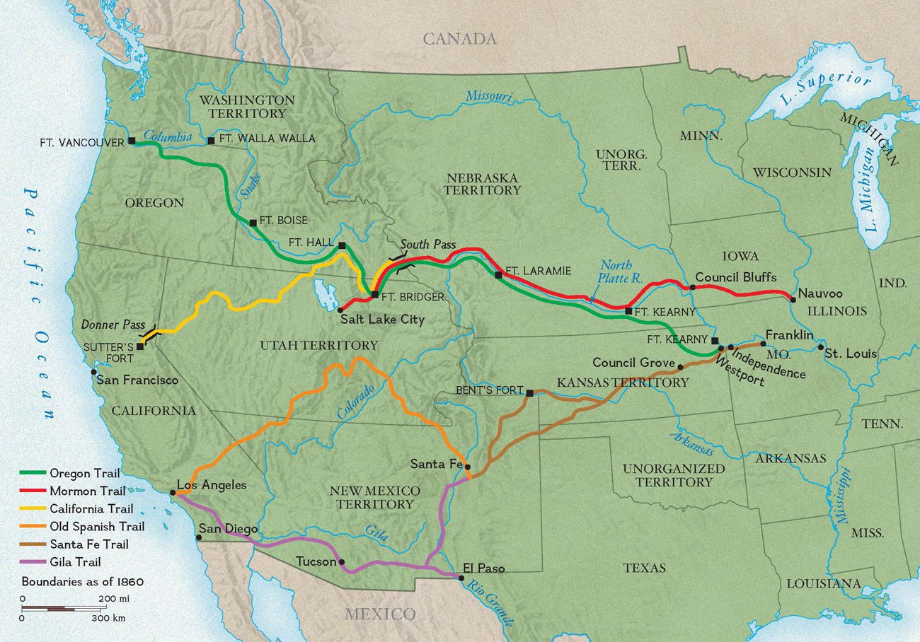
This map shows you the trails of the West: California trail, Mormon trail, Oregon trail, Santa Fe Trail, and etc. Notice all of the Forts on this map and other maps from the 1800's of the Oregon trail or Trails of the West, which suggests that these were heavily fought for and protected trading routes for the Blackamoors.

Flag of the Alaouite Dynasty.
The Moroccan flag of the Alaouite Dynasty, which ruled North Africa from 1666-1915. Notice that there is no 5 pointed star of this original Moroccan flag, because France added the 5 pointed star onto our flag after the defeat of the Muurs/ Indians in the war of 1812.

The Personification of America
"The personification of America,"is an old oil painting from the 16th Century (1500's). Notice that the Muur/ Indian is a Blackamoor and she is holding a solid red flag with the Islamic crescent Moon and star at the top of the flagpole. This old oil painting predates even the Alaouite Dynasty (1666-1915), which is more evidence to suggest that Islam came from the Orient (the Far East), which is the Americas. In this blog post I shared a link that demonstrate that Islam comes from the Americas, which is the Orient (East).

Flag of the District of Columbia
Hudson's Bay (Bey) Company Flag, aka, Flag of Oregon Country. More evidence to prove that the Moors and the British were allies is the Hudson Bay (Bey) Company Flag, aka, the Oregon Country Flag was first created in 1801, during the Old-World Order when Blackamoors ruled the world. Notice the unification of the Al-Moroccan flag with the Union Jack, aka, the British Flag. The Facebook link shared in this blog post about the 1907 Jamestown Expositions gives you 3 more examples of the unification of Moors and Jews/ Hebrews.

State Flag of Lebanon
The State Flag of the Islamic/ Arabic Lebanon in Europe. Notice that this state flag is very similar to the Continental Flag of the Washitaw Muurs, aka, the Flag of New England, which has a cherry red background with a pine Tree/ cedar tree on it (see both flags in this post of a comparison). In ancient times the Muurs or the Mound builders, aka, the Ancient ones, were known as the Tree people, because some of use to live in these giant cedars of Lebanon in marvelous tree houses, and were able to download all of the world's knowledge just by touching these giant cedars of God. Also, these giant cedars of God produced the God molecule called DMT in abundance. Additionally, these giant cedars of God were a great source of commence for our people, because these giant cedars of Lebanon produced the best wood in the world for lumber.

The Continental Flag, aka, Flag of New England
The Continental Flag of the Washitaw Muurs is very similar to the Islamic/ Arabic State flag of the Lebanon in Europe, since they both have giant cedars of Lebanon or pine trees on both of the flags, and they both have the Islamic Cherry red background on each flag too, which suggests that these were the same Washitaw Muurs that established the many Lebanon's in the Americas. North America has 29 Lebanon place names, which suggests that the Biblical Lebanon was in the Americas.

The First Compass
This is the First Compass, aka, the original compass and as you can see the Far East is actually the West. Yes, they flipped the maps on us. This is copyrighted material so I claim Fair use for educational purposes. This image is from Buxton and Skinner Company's 1904 "Ground plan of the Louisiana Purchase Exposition, St. Louis, MO, 1904

Moslem-Jerusalem
This is a closeup view of the 1904 ground map of the Louisiana Purchase. this map shows you Morocco, Illinois and Jerusalem all within close proximity with each other. This image is from Buxton and Skinner Company's 1904 "Ground plan of the Louisiana Purchase Exposition, St. Louis, MO, 1904.

Moslem-Jerusalem
This image is from Buxton and Skinner Company's 1904 "Ground plan of the Louisiana Purchase Exposition, St. Louis, MO. This map shows you a modern-day industry built around Morocco, Illinois and Jerusalem. This map also shows you the original compass before it was flipped to deceive the world.
Before we discuss, “Lower Jerusalem and Morocco was in Saint Louis Missouri,” previously we discussed the 1907 Jamestown Expositions, which was a great display of how the Muurs/ Tartars lived in marvelous Gothic and Greco-Roman Architecture in the Americas before the overthrow of the Muurs after the 1871 Reconstruction Act. Also, we discussed how the Moors and the British/English had become allies in the 1600’s to help defeat Spain after Spain had overthrown the Muurs in the Holy wars, aka, the Crusades between Moslems and Christians/Holy Roman Catholics in the Americas. Yes, Andalusia, which was a Moorish stronghold was in South America: https://www.facebook.com/Americaisthetrueoldworld/posts/3646074732123467. This post also proves that the 13 British colonies were established by Hebrews and Moors. More evidence to prove that the Moors and the British were allies is the Hudson Bay (Bey) Company Flag, aka, the Oregon Country Flag, which was first created in 1801, during the Old-World Order when Blackamoors ruled the world: https://en.wikipedia.org/wiki/Oregon_Country#/media/File:Hudson’s_Bay_Company_Flag.svg. Notice the unification of the Al-Moroccan flag with the Union Jack, aka, the British Flag. The Facebook link shared above in the first paragraph gives you 3 more examples of the unification of Moors and Jews/ Hebrews. The Oregon Country use to extend into part of Alaska, including present day Canadian province of British Columbia, all of the US states of Oregon, Washington, and Idaho, and parts of Montana and Wyoming, so we are talking about a huge piece of land here that was heavily fought for, considering all of the names of different forts on the map of Oregon Country that is in this post. Notice that this area was also called the District of Columbia, so we are dealing with the land of Virgin Mary, aka, the promised land. Learn more about the District of Columbia by reading this post: https://www.americaistheoldworld.com/ancient-greece-and-ancient-rome-was-in-old-world-america/. The giant cedars of Lebanon from the Bible are associated with the Holy land or the promised land. I believe that the Biblical Lebanon was Lebanon, Oregon, since California is known for giant trees (Redwoods) and Oregon used to be part of upper California. We also have to factor in Biblical place names like Salem (short for Jerusalem) Oregon, Lebanon Oregon, Canaan Oregon, Goshen Oregon, and Moab Washington, since the State of Washington was once part of Oregon Country, aka, the District of Columbia, which is Mary-land or Mauri-Tania (Maurs land). This Blog post, “Old Canaan in the New World,” demonstrates that America is the True Old World and that the Biblical Lebanon was in Lebanon Oregon: https://www.americaistheoldworld.com/old-canaan-in-the-new-world/. The architecture in Oregon Country suggests that a previous advanced civilization of Tartars/Blackamoors occupied Oregon Country, aka, the District of Columbia, since its Moorish or Tartarian (all one and the same people) architecture, which is Gothic and Greco-Roman Architecture, all over this area. This FB link reveals how great the State of Washington looked like: https://www.facebook.com/jesse.friebolin/posts/3841523092579765. In this post is three images of several obelisks found all over the State of Oregon. People associate Obelisks with only ancient Egypt; however, Obelisks are a Symbol of Mu/Atlantis, aka, Tartary, and they are found all over the world. The Obelisks were used in ancient times to generate and transmit free energy, wirelessly: https://www.facebook.com/Americaisthetrueoldworld/posts/3679206605476946. The Oregon Country is mostly known for the Oregon trail that was a 2,170-mile journey that ran along the mighty Missouri River that starts in Independence, Missouri, which is in Jackson County. Jackson means son of John and it means Yahweh is gracious. Independence Missouri is also the birthplace of Mormonism (Moor-men), since its founder Joseph Smith was from Independence Missouri. Joseph Smith lived during a time when Blackamoors ruled the Americas, which suggests that he was a Blackamoor since he was a Mormon (Moormen). Please read to post to learn that Joseph Smith was a Blackamoor presidential Candidate that was murdered by a mob of jealous angry whites that took over his religious cult and the leader of this mob took his name to become the new Joseph Smith and the leader of the Mormons: https://www.facebook.com/Americaisthetrueoldworld/posts/3700335696697370. The Oregon trail was established by Blackamoors in the 1830’s as a major commercial highway that connects with 4 other major trails: California trail, Mormon Trail, Bozeman Trail, and the Santa Fe Trail. The Oregon Trail ends in Oregon City, Oregon and it traverses the states of Kansas, Nebraska, Wyoming and Idaho, as well as briefly dipping into Washington as it follows the Columbia River along the Oregon state line. The interesting thing about these trails is that according to old maps from the 1830’s, it was battle forts built all along these trails, which suggests that these commercial highways were heavily fought for 30 years before the start of the Civil war in 1861, since these were valuable trading routes that connected the Golden Gate (California), the Silver Gate (Saint Louis Missouri), and the Lion’s Gate (Washington), aka, the Celestial Triangle or Triangle of Power. Please learn more about the Celestial triangle by watching this YouTube video by, “Caillea Crone & The Mystery of the Celestial triangle – Part 1 Saint Louis.” The said video has been embedded in this blog post for your convenience and please do enjoy. So, who were these Blackamoors fighting in the 1830’s before the Civil war? Were these Blackamoors fighting each other because they were in power during the 1800’s or were they fighting invading jealous European Incubator Babies that came after the great mud flood (global reset) of 1811-1812 by way of Orphan Trains to the South and by means of boats to Ellis Island to the North? Please watch Orphan trains by Jon Levi: https://www.youtube.com/watch?v=5CnPFjlciLM&list=LL&index=23. Well, the Blackamoors were fighting invading Europeans, whom had no home, that finally defeated the Blackamoors after the Civil war and rewrote history after the 1871 Reconstruction Act. Please read this Facebook post that demonstrates that the Blackamoors ran the South and the American Government before and shortly after the Civil war: https://www.facebook.com/Americaisthetrueoldworld/posts/2036032043127752. SAINT LOUIS MISSOURI WAS LOWER JERUSALEM AND MOROCCO:Lower Jerusalem and Morocco was in Saint Louis Missouri: https://www.loc.gov/item/97514011/. Walls of Jerusalem and the Ferris wheel looking from west restaurant pavilion, Louisiana Purchase Exposition, St. Louis, U.S.A. Image taken by N. Bennington, Vt. : H.C. White Co., c1904. Also, it was called New Jerusalem, which means old Jerusalem or ancient Jerusalem, because America is the True old World. Here is how New Jerusalem looked like according to the Library congress, which was 11 acres of land and over 300 buildings at the 1904 St. Louis World’s Fair: https://www.loc.gov/item/2013649750/. This area was also called the Jerusalem exhibit. Also, we have a 1904 ground map of the Saint Louis World’s Fair that shows you lower Jerusalem and Morocco was in Saint Louis Missouri. Keep in mind that both the Saint Louis Jerusalem and Morocco were both established before their Middle eastern reflections, since the State of Israel/ Jerusalem was established in 1948 and the State of Morocco was established in 1956. This map also shows you the original compass that indicates that the West is the far East. Yes…, the compass has been flipped, which suggests that the maps have been flipped as well! When you review the 1904 Ground map of the Saint Louis World fair you will see a thriving modern industry built around Saint Louis Jerusalem and Morocco. Was Morocco Saint Louis the same Morocco that recognized the UNITED STATES as a nation in 1777? Possibly, and if not, we have three other Morocco’s or Moroccan place names in the Americas that all predate the State of Morocco that was established in 1956. However, I believe that Morocco Indiana was the Morocco that first recognized the UNITED STATES, since the Muurs moved the Capital of America from Philadelphia pennsylvania to Chicago Illinois: https://www.facebook.com/Americaisthetrueoldworld/posts/1386675394730090. Read this post for the 4 different Morocco’s that we discussed previously on Facebook: https://www.facebook.com/Americaisthetrueoldworld/posts/1989361697794787. The four different Moroccan place names in the Americas suggest that the grand or the superior Morocco, aka, the Kingdom of Morocco or the Empire of Morocco, was in the Americas and the fabulous Gothic and Greco-Roman Architecture suggests the same. Even a pale Arab admits that the Kingdom of Morocco was in the Americas: https://www.youtube.com/watch?v=SE769mGmwHg. What was the Original flag of the Kingdom of Morocco or Almorocco? In this post is a image of the Moroccan flag of the Alaouite Dynasty, which ruled North Africa from 1666-1915. Yes, this flag was also the original flag of Morocco in which I will prove later on. Notice that there is no 5 pointed star on this original Moroccan Flag, because the 5 pointed star was added after the war of 1812. To support the image of the original Moroccan flag is an old oil painting from the 16th Century (1500’s) entitled, “The personification of America.” Notice that the Muur/ Indian is a Blackamoor and she is holding a solid red flag with no 5 pointed star on it, and the flag has the Islamic crescent Moon and star at the top of the flagpole. This old oil painting predates even the Alaouite Dynasty, which is more evidence to suggest that Islam came from the Orient (the Far East), which is the Americas: https://www.americaistheoldworld.com/america-is-the-true-old-world-vol-ii-ebook/ . In this blog post I demonstrate that Islam comes from the Americas, which is the Orient (East). Why is the Flag of the Maurs/Muurs red? Well, as Saracens (Moors), the Moors are the RED ONES/REDMEN, aka, the descendants of Saint Andrews, who was the First Apostle of Christ. The Flag of Saint Andrews is called the Red Shield, because it is Red with the phoenician Taw (X) on it: http://the-red-thread.net/genealogy/andrews.html. Saint Andrews was a Old Arab that was crucified on the Taw and had the same kind of wisdom and powers that Jesus had, I guess this explains why Jesus picked Saint Andrews, a Saracen (Old Arab), as his first Apostle, since he was a very worthy choice. Additionally, red is a color also associated with Blackamoor Royals, because Maurs/Muurs are the original Nobility, hence, the titles and phrases: the RED ONES, the Red men, the Red flag (Red Shield X), the Red Land (the Americas), the red Fez, the red Turban, the Red Belt, the Red Headband, Red blood, Tartarian red brick, and the Red Carpet for the biggest stars, aka, the Sirius beings that receive the Oscar/Arthur/Osiris/Ptah Award. Also, every Nations Flag has some red on it somewhere, which suggests that the Rus, aka, Rome, ruled the World; and the architecture all over the World suggests a Rus (Tartary/ Maur) Culture of Civilization. Those of us with a trained eye in Architecture know that the Maurs/Tartars built all of the Gothic and Greco-Roman Architecture all throughout the world, because you see a similar building style worldwide. However, their is a video and a book written on this Rus/Tartary (Moorish) topic called, “Construction of cities of the world by the Culture of Rus’s The ABCs of truth 24,” please watch it on youtube or either read the book if you will trust the book more: https://www.youtube.com/watch?v=odQbQM-wW-I&list=LL&index=34&t=294s. The Maurs/ Muurs as RUS/Ros/Andros/Andrews (Rus-Asians=Russians) Kings and Queens represented Islam, the Red flag/ Red shield, and the Russ-Asian (Russian) bear, which is on the Flag of the California Republic with an Islamic red 5-pointed star on it too. Russia was established by the mighty Andros/Andrews/Rus/Ros clan from Scotland when they were Saracens (Old Arabs), which explains all the Black “Russian Icons” and the Islamic state flag of Russia (RUS-Asian) with its Cherry red background and crescent moon and star: https://www.facebook.com/Americaisthetrueoldworld/posts/2104814609582828. More evidence that Lower Jerusalem was in Saint Louis Missouri is all in the art. For example, let us compare an image from the 1904 St. Louis World’s fair of Jerusalem’s Jaffa Gate with an image from the mid 1900’s of Jaffa Gate in Jerusalem in the so-called Middle East, as you can see the images are identical, which leads me to believe that the Jerusalem in the so-called Middle East that just recently became a state in 1948 was patterned after the Jerusalem that we first had in Saint Louis Missouri. Here is the source link to the mid 1900’s image of Jaffa Gate in Jerusalem that is in the so-called middle East, so that there can be no doubt that I did not manipulated the images: https://www.pinterest.com/pin/399342691962022435/. Yes, we busted them, family, because the duplicate image of Jerusalem, Saint Louis is clear evidence, since it is older (1904), that what they call the East is just a reflection or a copy of the Far East, (the Orient), which has been erroneously classified as the West or the New World by academics. Saint Louis Missouri was also a major trading hub or center of commerce, because this is where the mighty Missouri River and the mighty Mississippi River merge or become one river to form the longest River System in the World. Yes, the Mississippi River was your first Nile River and Ancient Egypt was in the Americas: https://www.americaistheoldworld.com/ancient-egypt-was-in-the-americas/. Since Saint Louis Missouri was a major trading hub it looked fabulous. Please read this Facebook post I did to see a video by Jon Levi to see how good Saint Louis and the Old World (Tartary) looked like before the destruction to hide a previous advanced civilization of Tartars/Blackamoors. This FB post also reveals the true meaning of Freemasonry, so please do enjoy it and thanks for reading. Peace: https://www.facebook.com/Americaisthetrueoldworld/posts/3358426734221603. The State of Missouri/ Mizraim (Egypt) is associated with the Promised land or the land of milk and honey, since you have Biblical places names like Lebanon, Canaan, and a Goshen in Missouri too, which also explains why Missouri looked so good, because it was the land of paradise, aka, the promised land of Israel. “But he did not hearken unto them, and dwelt in the land of Lebanon from Hamath to the entering of Egypt, he and his sons until this day. And for this reason that land is named Canaan.” —Jubilees 10:29-34. “God brought his people out from Goshen to the land of milk and honey and drove out the enemy before them with hornets (bees).” – Deuteronomy: 7:20; Joshua 24:12. Lastly, I know some of you are wondering where is Upper Jerusalem and Upper Egypt since we went over lower Jerusalem and lower Egypt? Well, if you purchase, “America is the True Old World, Volume II: The Promised Land,” by Amunhotep Chavis El-Bey, all of that information and more will be revealed, but in the meantime, I thank you for your time and your support. Peace. The post Lower Jerusalem and Morocco was in Missouri appeared first on America is the Old World. Via https://www.americaistheoldworld.com/lower-jerusalem-and-morocco-was-in-missouri/?utm_source=rss&utm_medium=rss&utm_campaign=lower-jerusalem-and-morocco-was-in-missouri
The First Compass
This is the First Compass, aka, the original compass and as you can see the Far East is actually the West. Yes, they flipped the maps on us. This is copyrighted material so I claim Fair use for educational purposes. This image is from Buxton and Skinner Company's 1904 "Ground plan of the Louisiana Purchase Exposition, St. Louis, MO, 1904

Old Canaan and ancient Egypt
This is a map of Old Canaan and ancient Egypt. As you can see the Biblical land of Canaan was in South America and ancient Egypt was in North America, which was known as the Orient (East), India Superior, and/or Asia Major. I have sources to authenticate this map too, because I have already written blog posts proving that "Ancient Mesopotamia was in the Americas," and "Ancient Egypt was in the Americas," which gives credence to this map as being factual. Plus, there is an area in South America near Guyana (Ghana) named, "Egypt Land of Canaan." Yes, Canaan (son of Ham/ Cush), aka, the Phoenicians, give birth the Ancient Egypt in North America. This is also Historically correctly too, according to Western academia since Cush or Ethiopia gave birth to Ancient Egypt in the North.

Canaan Valley State Park Trail map
This is a map of the Canaan Valley State Park Trail in Canaan Valley, West Virginia.

The Biblical Land of Old Canaan
This map shows you the Biblical Land of Old Canaan in the New World. The state of New HAMpshire has some interesting history, since the Biblical land of Canaan, Lebanon, and Goshen was in New HAM-shire (Hampshire) in North America, since it fits the description of the land of Canaan from the Bible: "But he did not hearken unto them, and dwelt in the land of Lebanon from Hamath to the entering of Egypt, he and his sons until this day. And for this reason that land is named Canaan." —Jubilees 10:29-34. "God brought his people out from Goshen to the land of milk and honey and drove out the enemy before them with hornets (bees)." - Deut: 7:20; Joshua 24:12. Additionally, there is a Canaan, Goshen, and a Lebanon in the State of Oregon.

Old canaan in the New World
Old canaan in the New World, is a book that demonstrates that Native Americans descend from the 12 tribes of Israel.
“Old Canaan in the New World,” is a blog that features the book, “Old Canaan in a New World: Native Americans and the Lost Tribes of Israel,” since this is book questions whether the indigenous Americans were descendants of the lost tribes of Israel.
Here is the book summary, “From the moment Europeans realized Columbus had landed in a place unknown to them in 1492, they began speculating about how the Americas and their inhabitants fit into the Bible. For many, the most compelling explanation was the Hebraic Indian theory, which proposed that indigenous Americans were the descendants of the ten lost tribes of Israel. For its proponents, the theory neatly explained why this giant land and its inhabitants were not mentioned in the Biblical record.
In Old Canaan in a New World, Elizabeth Fenton shows that though the Hebraic Indian theory may seem far-fetched today, it had a great deal of currency and significant influence over a very long period of American history. Indeed, at different times the idea that indigenous Americans were descended from the lost tribes of Israel was taken up to support political and religious positions on diverse issues including Christian millennialism, national expansion, trade policies, Jewish rights, sovereignty in the Americas, and scientific exploration.
Through analysis of a wide collection of writings—from religious texts to novels—Fenton sheds light on a rarely explored but important part of religious discourse in early America. As the Hebraic Indian theory evolved over the course of two centuries, it revealed how religious belief and national interest intersected in early American history.” [End quote from book summary from Amazon: https://www.amazon.com/Old-Canaan-New-World…/dp/B07ZKVNC6X].
I love the book cover because the Author is telling you that that the Garden of Eden and the Tree of Life is in the New World (the Americas). Notice that the Book cover has the Tree of life, Mother mary, or the Kaaba in the Center, which is surrounded by four pillars that signify the four rivers of life that flow into the Garden of Eden. Read more about the Garden of Eden right here please: https://www.americaistheoldworld.com/ethiopia-america-is-the-true-old-world-volume-ii-paperback/.
The state of New HAMpshire has some interesting history, since the Biblical land of Canaan, Lebanon, and Goshen was in New HAM-shire (Hampshire) in North America, since it fits the description of the land of Canaan from the Bible: “But he did not hearken unto them, and dwelt in the land of Lebanon from Hamath to the entering of Egypt, he and his sons until this day. And for this reason that land is named Canaan.” —Jubilees 10:29-34. “God brought his people out from Goshen to the land of milk and honey and drove out the enemy before them with hornets (bees).” – Deut: 7:20; Joshua 24:12. Additionally, there is a Canaan, Goshen, and a Lebanon in the State of Oregon.
We also have a Canada in North America, which was named after the Canaanites or the Khananland Muurs from Wa-Canada (Wakhanda). Let’s not forget the Canaan Valley State Park located in Canaan Valley, West virginia. Lastly, the grand Canyon was named after the Khanaanites/ Canaanites, since Canyon is a derivative of Kan or Can, which is short for Canaan or Canaan-on (Canyon). In this post is a map of South America being listed as Canaan and ancient Egypt as North America, and I have sources to authenticate it, since Ancient Mesopotamia was in the Americas: https://www.americaistheoldworld.com/ancient-mesopotamia-was-in-the-americas/., and so was ancient Egypt in the Americas: https://www.americaistheoldworld.com/ancient-egypt-was-in-the-americas/.
As you can see by viewing the map of Old Canaan and ancient Egypt, the Biblical land of Canaan was in South America and ancient Egypt was in North America, which was known as the Orient (East), India Superior, and/or Asia Major. I have sources to authenticate this map too, because I have already written blog posts proving that “Ancient Mesopotamia was in the Americas,” and “Ancient Egypt was in the Americas,” which gives credence to this map as being factual. Plus, there is an area in South America near Guyana (Ghana) named, “Egypt Land of Canaan”:https://www.stabroeknews.com/2013/11/17/sunday/beyond-gt/land-canaan/. Yes, Canaan (son of Ham/ Cush), aka, the Phoenicians, give birth the Ancient Egypt in North America. This is also Historically correctly too, according to Western academia since Cush or Ethiopia gave birth to Ancient Egypt in the North.
America is the Land of Milk & Honey, or the Promised land of Israel (Granada land): https://www.americaistheoldworld.com/granada-land-is-the-promised-land-of-israel/. This means that Old Canaan, Egypt, Jerusalem, Sumer, Babylon, and etc., was in the Americas, since the Americas is the land of the Bible and the true Far East. In this post is the original compass before it was flipped around to deceive us and the World. This original compass was taken from Buxton and Skinner Company’s 1904 “Ground plan of the Louisiana Purchase Exposition, St. Louis, MO, 1904. The East is associated with the land of the Bible and the Old World, therefore, since the Americas is the Far East, the Americas is the true old World. Peace.
The post Old Canaan in the New World appeared first on America is the Old World. Via https://www.americaistheoldworld.com/old-canaan-in-the-new-world/?utm_source=rss&utm_medium=rss&utm_campaign=old-canaan-in-the-new-world 
The dragon slayer
Hercules slaying the dragon in the garden of the Hesperides or the Garden of Eden that is guarding the Golden Apples of the Hesperides from theft, since these apples if eaten makes man a god.

The Atlantis Insula
1661 Sanson map of America as the Atlantis Insula. This map shows you that the Caribbean Islands were listed as the Hesperides. The Hesperides is significant because Hercules from the Pillars of Hercules on his quest to the garden of the Hesperides or the Garden of Eden.
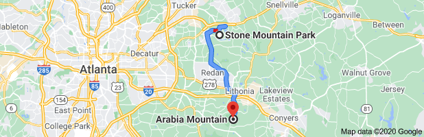
Map of the Rock of Gibraltar - Distance of 14 miles apart, so yes we do have two big rocks in the area known as New Gibraltar Square. These two big Rocks are the famed pillars of Hercules of Greek myth. The Rock of Gibraltar is Stone Mountain Georgia while the Arabia Mountain is the other Pillar known as Jebel Musa.

The Rock of Gibraltar and Jebel Musa
The Rock of Gibraltar and Jebel Musa (the Arabia Mountain) are two big rocks or pillars that are 14 miles apart, which suggests that these big rocks are the famed Pillars of Hercules of Greek myth. Look at how advanced the building grid is in this area, which suggest that a previous advanced civilization of Blackamoors once lived there. The building grid also suggest that the both pillars of Hercules were once Huge building structures that served a important purpose.

The Rock of Gibraltar
The Rock of Gibraltar in stone Mountain Georgia, as seen from the lake that surrounds it.
The Rock of Gibraltar is stone mountain Georgia was first revealed to me from a beauty melanite (dark) woman on youtube named “Unpacked with Ja’Nese.” She made a youtube video called “Breaking News: Stone Mountain is Gibraltar.” That video is embedded in this blog for your convenience. The said video is significant since the sister shows you a rare map of Georgia from the 1800’s that she paid $1400 dollars for that shows you that the Rock of Gibraltar is Stone Mountain Georgia, since the area was known as Gibraltar and you have two big rocks in that area. This interesting thing that I noticed about the Stone Mountain Georgia area is that in our present day time that area is known as New Gibraltar Square. This fact gives credence to the rare map that the beauty sister has blessed us with when she made her video, “Breaking News: Stone Mountain is Gibraltar.” This rare map also shows you BeerSheba, Georgia. You can still find Beersheba, Georgia on modern day maps. Beersheba is a Biblical city of Israel founded in 4000 BC, which is the fourth largest city in southern Israel. The sister mentions in her video the prophet Elijah came to Beersheba. She is right too, according to the KJV Bible Prophet Elijah fled to Beersheba, which belonged to Judah, “And when he saw that, he arose, and went for his life, and came to Beersheba, which belongeth to Judah, and left his servant there.” ~ 1 Kings 19:3. The sister mentions that the Rock of Gibraltar is associated with the Greek god Hercules, but who is Hercules? Well, Hercules was a Greek god that was the son of the Greek god Zeus, which makes Hercules half man and half god, since he was the Greek son of god or a Hero/ Heru (Horus). Hercules was a great Hero/ Heru (HERCU-les) that possessed superhuman strength, and he was able to perform 12 great labors, since he was the son of the Greek god Zeus. The 12 labors is the Sun/ Son (Hercules) going through each month of the year or each sign of the zodiac. The sister in the video is right again, because if you read, “The Pillars of Hercules,” the Rock of Gibraltar who was one of the Pillars of Hercules and is a portal or a gateway: https://en.wikipedia.org/wiki/Pillars_of_Hercules. In ancient times, the Pillars of Hercules was said to be located in the westernmost extremity of the inhabitable world. This description sounds like the Pillars of Hercules (one of the pillars is the Rock of Gibraltar) is located in the Americas, because in ancient times the Americas was known as the Westernmost extremity of the world, the land beyond, or the WEST. Also, if you read the History of the Pillars of Hercules, Plato, a great Greek philosopher, gave us a clue that the Pillars of Hercules is located near Atlantis (the Americas). Here is evidence that the Americas is Atlantis: https://www.americaistheoldworld.com/the-americas-was-atlantis-and-the-origin-of-the-ancient-egyptian-civilization/. Here is a quote from the “History of the Pillars of Hercules”: “Plato placed the fictional island of Atlantis beyond the “Pillars of Hercules”.[4] Renaissance tradition says the pillars bore the warning Ne plus ultra (also Non plus ultra, “nothing further beyond”), serving as a warning to sailors and navigators to go no further.[5] According to some Roman sources,[6] while on his way to the garden of the Hesperides on the island of Erytheia, Hercules had to cross the mountain that was once Atlas. Instead of climbing the great mountain, Hercules used his superhuman strength to smash through it. By doing so, he connected the Atlantic Ocean to the Mediterranean Sea and formed the Strait of Gibraltar. One part of the split mountain is Gibraltar and the other is either Monte Hacho or Jebel Musa. These two mountains taken together have since then been known as the Pillars of Hercules, though other natural features have been associated with the name.[7]Diodorus Siculus, however, held that, instead of smashing through an isthmus to create the Straits of Gibraltar, Hercules “narrowed” an already existing strait to prevent monsters from the Atlantic Ocean from entering the Mediterranean Sea.[8] In some versions, Heracles instead built the two to hold the sky away from the earth, liberating Atlas from his damnation.”[End quote from Wikipedia, “History of the Pillars of Hercules”]. According to the history of the Pillars of Hercules, Hercules on his way to the Garden of the Hesperides (the West, or the Garden of Eden), smashed through the Atlas Mountain and formed the Strait of Gibraltar. One part of the split mountain is the Rock of Gibraltar and the other is either Monte Hacho or Jebel Musa. These two mountains taken together have since then been known as the Pillars of Hercules. This means that the pillars of Hercules were formed as a result of Hercules on his quest to the garden of the Hesperides or the Garden of Eden, so knowing were the Hesperides is located at is key in the location of the pillars of Hercules. In this post is a 1661 Sanson map of the Atlantis Insula, and as you can see the Caribbean Islands is listed as the Hesperides Insula. The Caribbean Islands is an extension of North America (the adjoining islands), but is considered to be part of Central America now. This means that the Central Garden of the Hesperides or the Central Garden of Eden is the Caribbean Islands. This makes perfect sense, since we already know that we have a lower garden of Eden or lower Hesperides in North America and a corresponding upper Garden of Eden or upper Hesperides in South America. To confirm my statements as factual, please read my blog, “Ethiopia: America is the True Old World, Vol. II – Paperback”: https://www.americaistheoldworld.com/ethiopia-america-is-the-true-old-world-volume-ii-paperback/. The blog post also demonstrates that the Americas is Ancient Ethiopia (India), so enjoy this good read. In this post is a image of the Blackamoor Hercules wearing the skin of a mighty giant lion that he had killed with has bare hands on his quest to the garden of the Hesperides. The lion is symbolic of God because it poses strength, beauty, wisdom, and courage. This is why the ancient Egyptian Pharaohs would refer to themselves as the lion kings (the sphinx), because they would embody those attributes of God: strength, beauty, wisdom, and courage. Also, notice in the image the club Hercules is using to smite the dragon of the lower self, which is also a custom that came from ancient Egypt, since it was Pharaoh Narmer/ Nimrod that was first depicted on the walls of ancient Egypt Smiting an enemy with a club while wearing the mighty Jaguar/ leopard skin (the Black panther or Hero). I also have images of the Blackamoor Hercules wearing the Jaguar’s skin, which symbolizes a mighty hunter/ mighty warrior, so could the lion skin and Jaguar skin be interchangeable? I believe this to be the case, since both cats have the same attributes of God and both cats are kings. The Lion is the King of Africa while the Jaguar is the king of the Americas. I put emphasis on the skins, because the lion and the jaguar skin of the Magi priest-king or dragon-king, aka, superheros, became the cape of the kings and queens that currently rule the world. I Keep mentioning ancient Egypt because ancient Greece was a colony of ancient Egypt and all of the Greek gods were copied off of the ancient Egyptian gods. The Greeks and their Greek gods were Blackamoors: https://www.americaistheoldworld.com/ancient-greece-and-ancient-rome-was-in-old-world-america/. This blog post also demonstrates that ancient Greece and ancient Rome was in the Americas. The image in this post shows Hercules in the Garden of the Hesperides smiting a dragon that is protecting the Golden Apples. In ancient times dragons always guarded things of importance, like treasures for an example. The Golden apples of the Hesperides are said that if eaten one will attain supreme enlightenment and have everlasting life, so yes… these golden apples were extremely important and sacred (Holy). The Greek tale of Jason and the Argonauts is similar, since Jason had to defeat a dragon that was guarding the golden Fleece: https://www.facebook.com/Americaisthetrueoldworld/posts/3509662159098059. This Facebook post I did proves that the News Media is Medea. Medea was the Greek goddess of gossip and chaos. Notice that the dragon that Hercules and Jason both had to defeat was wrapped or spirals in a circle (circuit) around the Tree of life in the Garden of Eden. The wrapping of the serpent or dragon around the tree of life, or the Caduceus is symbolic of free energy, which is everlasting life: https://www.facebook.com/Americaisthetrueoldworld/posts/3568027483261526. Our DNA is also a serpent that spirals/ wraps to generate free energy. Whenever you have a spiral it creates a vortex of free energy that can be harnessed. The word Spirit comes from the word Spiral. Spirit mean energy. Energy is God according to scientist, since it is indestructible and always around us and it is this energy or spirit (Spiral) that makes all life move. In this post is a image of the Rock of Gibraltar from the strait or lake that surrounds it. You can see the reflection of it on the water too. It was always the custom of the Moors or the Tartars to build around water for extra protection and for the purposes of harnessing free energy. The Rock of Gibraltar is Moorish (Islamic) and it was named after a Moor named Tariq ibn-Ziyad, but what interests me the most is the suffix of Gibr-altar, which is Altar. An Alter is a place or Worship, usually in the form of a dome shape or a pyramid in ancient times. When I look at the Rock of Gibraltar it appears to be a ancient place of worship that was either a dome or a Mayan step pyramid that was ruined due to man trying to suppress history, and due to a global heat event that cooked buildings and other weather conditions that petrified huge building structures into stone mountains: https://www.youtube.com/watch?v=QbpfZEfnDCQ. The Youtube video I just shared is from a youtube channel called, “When the Buildings Cried.” The name of the youtube video is “When Buildings cried and turned into stone from a world wide heat event.” This video gives overwhelming evidence to suggest that most of our Mountains were once huge buildings that melted. When you look at the Grand Canyon this is certainly the case, because I see melted buildings all throughout the grand canyon. Check out the other videos on this youtube channel if you need more evidence. Also the building grid around the Rock of Gibraltar suggest that it was once a building that was the source or center of the building grid in that area. In this post is a image of Stone Mountain Georgia, the Arabia Mountain, and the Arabia High School. Notice the advanced building grid in the area, but it is now mostly covered by trees, but you can still see the layout of the previous advanced civilization of Blackamoors that once lived their and still do live their, because Dekalb county is still a predominantly Moorish (Black) County and it is only a 18 minute drive from the Greek (Creek) Atlanta, Georgia, which also is a predominately Blackamoor City. This evidence all ties in because the original Arabs and Turks were Blackamoors: https://www.americaistheoldworld.com/the-original-arabs-were-blackamoors/. This blog post demonstrates the the original Arabs and Turks were Blackamoors, and this post shows you the strong connection between Islam and judaism, since this blog link shows you ancient Islamic coins of the Lion of Judah and the 6 pointed Star of David that belonged to the Turks/ Moors. Yes, the Moors or Turks were Jews or Hebrews with Islamic customs. I have another image of Stone Mountain Georgia (the Rock of Gibraltar) and the Arabia mountain (Jebel Musa) that shows you the close distance between both of these stone mountains or Pillars of Hercules, which is only 14 miles apart, so yes we do have two big rocks in that area as the sister mentioned in her great video. This means that the Arabia mountain has to be the other Pillar of Hercules, which was called Monte Hacho or Jebel Musa by the Moors or the Turks. Also, notice on the same map image you have a Jersey, Georgia. Jersey is short for Jerusalem. When viewing the said map you will also notice cities with Moorish or Arabic place names like Tucker (Turk) and Lithonia (Lithuania). Lithuania was established by the Turks or the Moors and used to be part of Russia. Rus-Asian (Russia) was established by the Andrews/ Andros/ Ros/ Ras/ Russ family from Scotland when this family were still Saracens (Moors). Evidence of this fact is the Moorish flag that the Russians still claim as their own with the Red Background and the Islamic crescent Moon and Star, and the Tartarian or Moorish architecture (Gothic architecture) found all throughout Russia; which suggests that Moors (Blacks) once ruled Russia. The Andrews family were descendants of Saint Andrew, the first apostle, and this family crest is represented by the Saracen’s head or the Moor’s head: http://the-red-thread.net/genealogy/andrews.html. Yes.., so-called Blacks in the Americas are really Jews/ Hebrews with Islamic customs, aka, Turks or Moors (Berbers). This makes sense because Christopher Columbus came to the Americas to capture Moslem-Jerusalem and the Americas was called Granada land (Israel or the Promised land) as a whole. We all know that Granada was a Moorish stronghold and the term Saracen pertains solely to Moors: https://www.americaistheoldworld.com/granada-land-is-the-promised-land-of-israel/. This blog post proves that Granada land (the promised land of Israel) was the Americas and that it was a Moorish stronghold. Lithuania today is still predominantly a Muslim Country of Turks and so is its partner Georgia in Europe. We have a strong connection with place names between the European and the American Georgia and Lithonia (Lithuania), so did the same American (Al-mor-roco=Al-Meri-khan=American) Moors or Turks establish the Georgia and Lithuania in Europe as a reflection of what they already had in the Americas? Yes.., they did because civilization came from the Americas and spread out to the rest of the world (see Home page of this website or either read the Book sample of America is the True old World). Why is the European Georgia and Lithuania still Islamic and the American version consists of Blackamoors that are mostly christians? Well, because we all know that most Blackamoors in the Americas have been indoctrinated to be Christians, via, the edict of the Worms (dragons) issued by Holy Roman Emperor Charles V, which banned Islam in the late 1400’s; plus the dum diversa of 1452 (the doctrine of Discovery), which authorized Christians to take land and possessions or Saracens and pagans. Yes, the Moors or Turks of the Americas were forced to convert to christianity or be killed when the Americas were invaded by Holy Roman Emperor Charles V, and company, in the early 1500’s. Likewise, the Moors of spain were treated the same way. The rare map in the video also shows you Lebanon, Georgia, which is a Biblical city that is mentioned over 71 times in the KJV Bible. You can find Lebanon Georgia on modern day maps too, but the area has now become part of Holly Springs. The Biblical Lebanon was established by the phoenicians (Canaanites). The Phoenicians/ Canaanites were moslem Moors with Hebrew Israelite customs. Lebanon today is still mostly a Arab or a Islamic State in the Middle East. The interesting thing about Lebanon…, is that in several instances, the Old Testament claims the land of Lebanon as part of the territory of Israel (Deuteronomy 1:7, 3:25, 11:24; Joshua 1:4, 11:17, 13:6; 1 Kings 9:19 par; Chronicles 8:6; Zechariah 10:10). In other instances, the writers of the Old Testament think of Lebanon as the northern boundary of the land God promised to his people (Joshua 1:4, 9:1f., 11:17, 12:7, 13:5; Judges 3:3). In two instances (Joshua 13:5; Song of Songs 4:8), “Lebanon” is used to describe all the hill country in middle Syria. We also have a Lebanon, Canaan (Phoenicians), and Goshen in New Hampshire: https://www.facebook.com/Americaisthetrueoldworld/posts/3579305175467090. All of which are Biblical cities that are associated with the Children of Israel. We also have a Shiloh, Georgia, and Jerusalem, Georgia, which are both Biblical cities that are heavily associated with the Children of Israel. Georgia is Cherokee Territory and the name Georgia is also a Greek name. The Cherokee (the Cherry Tree: Ole glory, i.e., the Moroccan flag) were Moors that ran the South and owned white slaves. The Confederate flag was the flag of the Iroquois confederation and it was the Battle flag for the Moors who owned and ran the South: https://www.facebook.com/Americaisthetrueoldworld/posts/2036032043127752. More evidence that the Cherokee were Moors is Cherokee Gothic Architecture. Gothic Architecture is a Tartarian or a Moorish mode of workmanship, according to the master text, “A Dictionary of the Architecture and Archaeology of the Middle Ages”: https://www.facebook.com/Americaisthetrueoldworld/posts/2578185658912385. More evidence that the Cherokee are Moors is my family ancestry, since I am a descendant of Ishmael Chavis, who was a Cherokee Indian Chief from North Carolina in the late 1700’s. Also Prophet Noble Drew Ali was from the Cherokee Indian Tribe. Additionally, this July 1996, “Article,” I found from Message Magazine called, “Digging for the Red Roots,” confirms that the Cherokee were Moslem Mu’urs/ Berbers: “My name is Mahir Abdal-Razzaaq El and I am a Cherokee Blackfoot American Indian who is Muslim. I am known as Eagle Sun Walker. I serve as a Pipe Carrier Warrior for the Northeastern Band of Cherokee Indians in New York City. There are other Muslims in our group. For the most part, not many people are aware of the Native American contact with Islam that began over one thousand years ago by some of the early Muslim travelers who visited us. Some of these Muslim travelers ended up living among our people. For most Muslims and non-Muslims of today, this type of information is unknown and has never been mentioned in any of the history books. There are many documents, treaties, legislation and resolutions that were passed between 1600s and 1800s that show that Muslims were in fact here and were very active in the communities in which they lived. Treaties such as Peace and Friendship that was signed on the Delaware River in the year 1787 bear the signatures of Abdel-Khak and Muhammad Ibn Abdullah. This treaty details our continued right to exist as a community in the areas of commerce, maritime shipping, current form of government at that time which was in accordance with Islam. According to a federal court case from the Continental Congress, we help put the breath of life into the newly framed constitution. All of the documents are presently in the National Archives as well as the Library of Congress. If you have access to records in the state of South Carolina, read the Moors Sundry Act of 1790. In a future article, Inshallah, I will go into more details about the various tribes, their languages; in which some are influenced by Arabic, Persian, Hebrew words. Almost all of the tribes vocabulary include the word Allah. The traditional dress code for Indian women includes the kimah and long dresses. For men, standard fare is turbans and long tops that come down to the knees. If you were to look at any of the old books on Cherokee clothing up until the time of 1832, you will see the men wearing turbans and the women wearing long head coverings. The last Cherokee chief who had a Muslim name was Ramadhan Ibn Wati (see Figure 34) of the Cherokees in 1866. Cities across the United States and Canada bear names that are of Indian and Islamic derivation. Have you ever wondered what the name Tallahassee means? It means that He Allah will deliver you sometime in the future [end quote]. Turin, Georgia and Moreland Georgia are cities located in Coweta County, Georgia. Both of these cities are Moslem or what you would call Muurish/ Moorish in nature with names like Moreland and Turin (Turk). Speaking of Turks, we have the Turks of South Carolina, we have a Turkeytown, Alabama and we have a Turkey, Alabama. Alabama is even Arabic, since you have Allah in Alabama (Allah-ba-ma). Alabama and Georgia are sister states since they are neighboring states, and since they have virtually the same State Flag. You have over 500 Arabic place names of cities all over the Americas, which suggests that the Americas was in fact Moslem-Jerusalem: https://www.americaistheoldworld.com/america-is-the-true-old-world-vol-ii-ebook/. In conclusion, family and friends, based upon all of the above facts and the authorities cited herein, the Rock of Gibraltar is stone Mountain Georgia (one of the Pillars of Hercules) while the Arabia Mountain is the other pillar of Hercules, which was called Monte Hacho or Jebel Musa by the Turks/ Moors. We also have a Gibraltar in Michigan, but it’s nothing like the Rock of Gibraltar in Stone Mountain, Georgia. The post The Rock of Gibraltar is Stone Mountain, GA appeared first on America is the Old World. Via https://www.americaistheoldworld.com/the-rock-of-gibraltar-is-stone-mountain-ga/?utm_source=rss&utm_medium=rss&utm_campaign=the-rock-of-gibraltar-is-stone-mountain-ga 
Ancient Ethiopia
Figure 27: map of Ethiopia in South America. This map is very significant because Ethiopia is the land of Cush and the Birthplace of Ancient Egypt. Yes, Ancient Egypt was also in the Americas. This map also shows you Cartago (Carthage) and Mauritania (the land of the Moors) in south America, so yes the Moors (Blacks) are indigenous to the Americas and the world.

Ancient Ethiopia
Figure 26: map showing you Ethiopia in South America. This map is very significant because Ethiopia is the land of Cush and the Birthplace of Ancient Egypt. Yes, Ancient Egypt was also in the Americas.

Ancient Ethiopia
Figure 25: Map showing South America as Ethiopia. This map is very significant because Ethiopia is the land of Cush and the Birthplace of Ancient Egypt. Yes, Ancient Egypt was also in the Americas.

The Tree of Life
Figure 24: Mount Roraima is the highest point in Guyana (Ghana). Mount Roraima is 9 miles long and 9222 feet tall. Mount Roraima sits director on the Equator of the Earth and is the source of three mighty rivers, one of which is the Amazon.

1595 Mercator Map of the North Pole
Old world 1595 Mercator map of the Arctic North pole. Notice Mount Meru, which is the black magnetic mountain, aka, the Kaba, at the center in the lake, which is our magnetic North pole that aligns perfectly with the Pole Star or North Star.

1597 map of Hyperborea by Abraham Ortelius.
Old World 1597 map by Abraham Ortelius of Amsterdam, showing "Hyper Borei" (Hyperborea) in the Arctic North Pole. I believe this map is much older because the land is not divided yet. You can also see that Atlan (Atlantis) was in the American region on this map, which is another map that verifies that the Americas is Atlantis. Notice how the North pole was once a warm and lush area, because according to this map the North pole is not covered with ice; therefore, civilization could have come from the North in accordance with many myths.

1595 mercator Map of the North Pole shown as Eden and Meru
Old World 1595 Mercator map of the Arctic North Pole, and as you can see someone listed Eden and Meru right there. But why?Well, because the KJV Bible lists 4 rivers in association with the Garden of Eden and you can see 4 rivers and the Black cube (the Kaba or the tree of life) in the center of the lake where the rivers emanate from that represents the Tree of life in the Garden of Eden. Notice how the land mass looks just like the swastika (black spirit). What is the Swastika? Well, the Swastika is the clockwise rotation of the constellations around the Pole Star/North Star, which creates the electromagnetic energy that creates and sustains life.
The First Compass
This is the First Compass, aka, the original compass and as you can see the Far East is actually the West. Yes, they flipped the maps on us. This is copyrighted material so I claim Fair use for educational purposes. This image is from Buxton and Skinner Company's 1904 "Ground plan of the Louisiana Purchase Exposition, St. Louis, MO, 1904

India Superior
Old world map of India Superior in North America. I took this map from a book called, "The Journey of Coronado," by Castañeda de Nájera, Pedro de, 16th cent. The book cover displays the 1569 Mercator world map which shows India Superior being in North America. This is evidence that the Americas is the old world, because the Americas is the Orient (the East). Notice India Superior and La China on this old world map.

Asia Major
Map of Asia Major as North America - 1531, by Orontius Fine. Yes, North America was once India Superior (Asia), aka, the Orient (East).

PURCHASE NOW ON AMAZON
America is the True Old World, volume II: The promised land, is now available in Paperback on author's site or on Amazon
Ethiopia: America is the True Old World, Vol. II – Paperback, is the ancient American history book that you all have been waiting on, since this book is destined to rewrite history with the discoveries contained within this book. This book comes complete with 9 chapters and with over 70 color illustrations to highlight the beauty and sophistication of the old world. This book is not your traditional history book; therefore, it is not for the faint hearted. This ancient American history book is jam-packed with information and after reading this revolutionary history book, you will never look at history the same way again, because history is not how we know it. Could the East really be a reflection of the West? Is the West really the far East? This book will answer these questions for you and some more. If you love to think outside of the box, and are just fed up with the lies of traditional history books, this is your history book, and I assure you that you will love it. America is the True Old World, vol. II – paperback, challenges the status quo with the discoveries of ancient Mesopotamia, ancient Egypt, India Superior, Sumer, Cush, Ethiopia, Ancient Ghana, Jerusalem, the Kingdom of Mali, Timbuctoo, the Kingdom of Fez, Tripoli, Mecca, Morocco, Mauritania, ancient Arabia, Rome & Greece, the garden of Eden, cities of gold (Cibola and El Dorado), and so much more, all located in the Americas. Yes, all of the said places where all in the Americas, first, since America is the True Old World. If you have a friend or a family member with an open mind that loves to think outside the box, then get them this good read as a present. I am a firm believer that knowledge is the best gift, because you can do so much with knowledge. “Knowledge is power.” ~ Ole saying. This history book also debunks the Transatlantic slave trade story, as being told to us in reverse, because the Americas has always been a Negro Continent, which means that it would have been a lot easier and cheaper just to enslave the copper-colored Native Americans (Blackamoors) that were already in the Americas way before Christopher Columbus. Please get your paperback copy of “America is the True Old World, Vol. II: The Promised Land,” from the author’s site or from Amazon: https://www.americaistheoldworld.com/product/america-is-the-true-old-world-volume-ii-paperback/. Embedded in this blog post is a promotional YouTube video for my new book, America is the True Old World, Vol. II. Please enjoy this video book sample and also the written book sample in this post below. America is the True Old World, Vol. II – Paperback: Book Sample:CHAPTER III: ANCIENT ETHIOPIA WAS IN THE AMERICAS.LOWER ETHIOPIA WAS IN NORTH AMERICA:The term Ethiopian in ancient times did not just refer to just a region of people in Ethiopia, Africa. The term Ethiopian applied to anyone with dark or burnt (Black) skin. According to the book, “Lost Tribes and Promised Lands,” by Ronald Sanders, “But Ethiopian served to designate color before it came to be applied to a region; the Greek Aithiops, from which it is derived, literally meant Burnt Face and referred to any person of black complexion, whatever his place of origin. Homer said of the Ethiopians that they live at the ends of the Earth, some near the Sunrise, some near the sunset. In latter antiquity the world tended to become restricted to Black Africans, meaning either any Negro or someone specially from Ethiopia. The Biblical terms Cush and Cushi, which may have been specifically geographical designations from the outset, came to be translated Ethiopia and Ethiopian respectively, and the ambiguity was thereby reinforced.” [end quote]. This quote suggests that all so-called Black people or Negroes are Ethiopians. I already hint at lower Ethiopia being in North America at the Arctic North Pole, aka, Mu/Meru/Meri/Mary (Mother Mary), in my previous book, “America is the True Old World,” when I demonstrated in Chapter II of that book that the Americas was India Superior (Asia Major); because the Arctic North Pole was the mythical Garden of Eden, and hence, Lower Cush or Lower Ethiopia as a result, because the Cushite’s were Ethiopians. I will further expound upon this information, so that there is no doubt that Ethiopia was in the Americas. Civilization came from India Superior, which was in North America (see Figures 11, and 12). Yes, North America was once Asia, aka, the Orient (East), aka India Superior. In this chapter is an old-world map by Orontius Finaeus from 1531 and a 1548 Spanish World map showing you India superior (Asia Major) and China being in North America, which is the true Orient or the far East. “The Orient is a term for the East”: https://en.wikipedia.org/wiki/Orient. I did a blog post, “The Old World is the New World,” which demonstrates that the Americas is Asia Major and I gave an image of the original compass that shows you that the Far East was actually our modern-day West (see Figure 13: the Original Compass). This blog post and Figure 13 proves that they flipped the maps on us, because the Americas is the True old World: https://www.americaistheoldworld.com/the-old-world-is-the-new-world/. In my previous book, “America is the True Old World,” Volume I, and in the blog link I just shared above, I demonstrated that India is the oldest civilization and that Atlantis was a colony of India. However, little do we know that Ethiopia was also a colony of India according to the book, “Wonderful Ethiopians of the ancient Cushite Empire:” Chapter XV – The Civilization of India, “It is a common error to suppose that the tribes that the Aryan invaders found were savages. Ancient annals represented the Cushite Indi as wise and skillful. Heeren said that these writings represented the early Hindu as a commercial people, that their merchants could travel from one of the Nile flowing through Barabra (Ethiopia) and the mountains of the Moon. Even the name Hindu is Ethiopian. Ancient records of authority made Hind and Sind sons of Cush. Philostratus. in Vit. Apollon (Lib. II), says, “The Indi are the wisest of mankind. The Ethiopians are a colony of them, and they inherit the wisdom of their fathers.” The separation of India from the parent Cushite stock was in ages long before the rise of the so-called Aryans in India. The older Greeks always associated the sacred waves of the Indian Sea with the wonderful Ethiopians. Ephorus stated that they occupied all the southern coasts of Asia and Africa. As in Chaldea they brought to the aboriginal tribes of India the knowledge of metals to take the place of stone implements, they brought the knowledge of the arts. Their funeral remains all over India reveal the stone circles and upright massive menhirs of North Africa. They understood in those far distant ages how to make hard earthenware, iron weapons and ornaments of gold. Today in a state of degenerated art, Sind is the only province where the potters craft is artistic. Before Megathenes, a Greek ambassador to the court of the non-Aryan Chandra Gupta, about 300 B. C., the Greeks mentioned as Indi only the Cushites of the areas between the Hindu Kush and Persia. The name India means black, and Condor thinks that it was employed only to designate the home of the Asiatic Ethiopians.” [End quote from: http://theology101.org/afr/we/we17.htm]. The fact that the West is the far East is significant, because it is well-established that the East is the Old World, according to Western academics. The original compass (see figure 13) suggests that the so-called West is the Old World. The East (West) is also the location of the Biblical Garden of Eden or the Hesperides, according to learned theologians. “St. Isidore, Bede, Strabo, and Scotus, and all the learned theologians, agree that the earthly paradise is in the East.” [end quote from “The Select letters of Christopher Columbus – Third Voyage of Columbus”]. Central America was described as the Hesperides, according to the book, “Prehistoric Structures of Central America who Erected them,” by Martin Ingham Townsend, “The Soil, climate and productions of the Peninsula of Yucatan, and that part of Mexico and Guatemala where these prehistoric remains are found, are precisely what are described by the European writers who speak of the beauty, the loveliness and the grandeur of the Hesperides (the West) and the homes founded by Eastern adventures beyond the Western Ocean.” [end quote]. The Hesperides means the Garden of the Hesperides, aka, the Garden of Eden. Hesperides also means the West and the evening star (Venus: love). The meaning of the Hesperides suggests that the Garden of Eden was in the West (the Americas), which is the Far East (see Figure 13). More evidence that the Garden of Eden or the Garden of the Hesperides is in the Americas is the book, “Atlantis: The Antediluvian World, by Ignatius Donnelly, “That it [America] was the true Antediluvian World: The Garden of Eden; the Garden of the Hesperides; the Elysian Fields.”[end quote]. According to “Prehistoric Structures of Central America who Erected them, by Martin Ingham Townsend, “Let us look for a moment at some of the things which the Ancient Greek and Latin authors have said indicating their knowledge of the existence of a Western Continent. Crates, a commentator on Homer, is quoted by authority of Strabo, a very learned author of the century before Christ, as saying that Homer means in his account of the Western Ethiopians the inhabitants of Atlantis or the Hesperides, as the unknown world of the West was variously called.”[end quote]. More proof that the Americas (Atlantis) is the Garden of Eden is the book, “Atlantis: The Antediluvian world,” by Ignatius Donnelly, “Atlantis is the Garden of Eden.” Also, if you have read Volume I of my book, “America is the True Old World,” by Amunhotep El-Bey, you know that the Americas is Atlantis and the true Old World. If you have not read volume I of my book, I did a blog post that will brief you on this topic, entitled, “The Americas is Atlantis and the Origin of the Ancient Egyptian Civilization”: https://www.americaistheoldworld.com/the-americas-was-atlantis-and-the-origin-of-the-ancient-egyptian-civilization/. In addition, according to the book, “Atlantis: The Antediluvian world, by Ignatius Donnelly, “The Pyramid. – Not only are the cross and the Garden of Eden identified with Atlantis, but in Atlantis, the habitation of the gods, we find the original model of all these pyramids which extend from India to Peru.” [end quote]. I must note that North America (Asia Major/ India Superior) by itself has more pyramids than all of Africa combined. Now, if we include all the Americas (North, South, and Central) then it is not a contest anymore as far as who has the most pyramids. I presented this evidence already in Volume I of my book, “America is the True Old World, however, my book sample will prove my point that the Americas is Atlantis because it is way more pyramids (the symbol of Atlantis) in the Americas than in Africa: https://www.americaistheoldworld.com/america-is-the-true-old-world/. More evidence that the Americas is the Garden of Eden (Atlantis) is the fact that Mount Meru/MU (see figure 14) is the Emblem of the Garden of Eden, according to the book, “Atlantis: the Antediluvian world,” by Ignatius Donnelly, “in the great ditch surrounding the whole land like a circle, and into which streams flowed down from the mountains, we probably see the original of the four rivers of paradise, and the emblem of the cross surrounded by a Circle, which, as we will show hereafter, was, from the earliest pre-Christian ages, accepted as the emblem of the Garden of Eden.” [end quote]. Yes, according to figures 14 and 16, because these images fit the description of the Garden of Eden, perfectly, therefore, the Artic North pole (Mount Meru) was indeed the Garden of Eden or the Garden of the Hesperides. All life and civilization came from the uppermost region of India Superior (Asia Major), which is the Artic North pole, aka, Mount Meru/ Meri/ Mary/ MU/ MR (Goddess Danu/ Anu); which is the mythical Garden of Eden (see figure 14), Hyperborea (see figure 15), and the Garden of the Hesperides. “It is in the mythical that we have the truth” ~ Greek proverb. Genesis of the KJV Bible, 2:10–14, lists four rivers in association with the garden of Eden: Pishon, Gihon, Chidekel (the Tigris), and Phirat (the Euphrates). It also refers to the land of Cush—translated/interpreted as Ethiopia. Ethiopia is a Greek word which means burnt face or sun darken people, aka, Blacks/Negroes. “Ethiopia and India were often confused,” [one and the same] according to the book “The Medieval Empire of the Israelites,” by Robert Grishin. This makes sense when you factor into account that the Swastika [symbol of Brahma/Abraham], which means Black spirit, was the chief religious’ symbol in Ancient Ethiopia and in India. “With regard to the Ethiopians, Strabo indicates that they looked similar to Indians, remarking “those who are in Asia (South India), and those who are in Africa, do not differ from each other.” [10] Turner, Sharon (1834). The Sacred History of the World, as Displayed in the Creation and Subsequent Events to the Deluge: Attempted to be Philosophically Considered, in a Series of Letters to a Son, Volume 2. Longman. pp. 480–482. Retrieved 20 January 2015. [end quote from https://en.wikipedia.org/wiki/Aethiopia]. This makes sense because the Americas was once India Superior, and it is already firmly established that so-called Black people were your first people. You can tell by looking at figures 14-16 that the MU/ Motherland (Mary) region used to be a warm and lush region, so yes, civilization could have started from the North, in accordance with so many myths. Figure 14 is an unknown map of the Arctic North Pole, and as you can see the Garden of Eden and Mount Meru right there. The Bible lists 4 rivers in association with the Garden of Eden and you can see 4 rivers and the Black magnetic cube (the Kaba: Mecca) in the center of the lake where the rivers emanate from that represents the Tree of Life in the Garden of Eden (see figure 14 and Figure 16). UPPER ETHIOPIA WAS IN SOUTH AMERICA:The Garden of Eden is associated with the land of Kush/Cush in Ethiopia. Now, that we know that Lower Ethiopia was in North America, where is the corresponding upper Ethiopia? I say corresponding because of duality (opposites), which is a fact in nature. The law of correspondence (As above so below) suggests that there must be another Garden of Eden in the Americas. Mount Roraima in South America, near the highest point of Guyana (Ghana), gives us a clue as to where is the upper Garden of Eden, because according to Native legend it was once a mighty tree that reached all the way into the heavens and it produced every fruit and vegetable in the world. Legends says that when this tree was cut down it caused the great flood. There is evidence of giant trees that once reached all the way up into the heavens. The Bible speaks of these giant trees: Daniel 4:11 The tree grew, and was strong, and the height thereof reached unto heaven, and the sight thereof to the end of all the earth; Ezekiel 31:3 Behold, Assyria was a cedar in Lebanon, with beautiful branches and forest shade, and of towering height, its top among the clouds; and Psalms 80:10 The mountains were covered with its shadow, And the cedars of God with its boughs. In this Chapter is evidence of one of those giant trees called Mount Roraima, aka, “The Tree of life” (see figure 24). Mount Roraima is 9 miles long and 9222 feet tall, now, this is a huge tree! Mount Roraima is the source of three mighty rivers, one of which is the amazon river. Figure 24 shows you four waterfalls coming from the top of Mount Roraima, which are the source of three rivers. When Christopher Columbus came to the New World he was also in search of the Garden of Eden. When he saw Mount Roraima he knew that he had found his paradise, because this mighty tree stump puts out so much fresh clean water (life) that it had to be the mythical TREE OF LIFE and this tree is also positioned at the Center of the world, just like the Garden of Eden is/was. Mount Roraima sits right on the Equator of the Earth. Here is a description from Christopher Columbus of the Orinoco River in South America: “The river, he was persuaded, must be rushing down from the summit of the earth, where the lord had planted the earthly paradise, in the midst whereof was a fountain whence flowed the four great rivers of the world.”[End quote from the book, “Narrative and Critical History of America, edited by Justin Winsor]. The river rushing down the Summit that Christopher Columbus was referring to is Mount Roraima because it has fresh water rushing down from its summit and it is the source of three mighty rivers (see figure 24). Here is a description from Christopher Columbus of Mount Roraima in South America: “The approach to it from a distance must be by a constant and gradual ascent; but I believe that, as I have already said, no one could ever reach the top; I think also, that the water I have described may proceed from it, though it be far off, and that stopping at the place which I have just left, it forms this lake. There are great indications of this being the terrestrial paradise, for its site coincides with the opinion of the Holy and wise theologians whom I have mentioned; and moreover, the other evidences agree with the supposition, for I have never either read or heard of fresh water coming in so large a quantity. I think that if the river mentioned does not proceed from the Terrestrial paradise, it comes from an immense tract of land situated in the South, of which no knowledge has been hitherto obtained. But the more I reason on the subject, the more satisfied I become that the terrestrial paradise is situated in the spot I have described.” [End quote from, “Select Letters of Christopher Columbus” – third Voyage of Columbus]. A tree this size puts out a lot of Oxygen, which makes it very possible to have giant-sized everything because the oxygen level of the Earth was so high, back in those days. The Jurassic era is a time when everything was giant-sized, so why is it so hard for people to believe in giant-sized people and the giant trees that supplied the oxygen? Mount Roraima is not the only flat top mountain in this area either because there are many of flat top mountains (trees) in this area and there are many all around the world. One of our ancient names as a people was, “The Tree people.” We used to be able to go up to these trees and touch them and naturally download all the world’s knowledge. Additional evidence that Upper Ethiopia was in South Americas is the three maps (see figures 25-27) in this chapter that shows you that Ethiopia was in South America. Are these maps correct? Can we trust these maps? Yes, because according to the Bible and Common law the testimony of two or more witnesses is truth. I have provided 3 maps that Interlock with each other. Interlocking testimony is when the witnesses say the same thing. Sure, we can fight with these maps because we have 3 witnesses (maps) that said the same thing; however, let us take it a set further by summarizing all of the evidence to prove that the Americas was Ancient Ethiopia: (1.) Punt, the birthplace of Ethiopia and Egypt, was in South America (see blog post: “Ancient Punt was in South America”: https://www.americaistheoldworld.com/ancient-punt-was-in-south-america/. ); (2.) the Garden of Eden was in the Americas, which is heavily associated with Ethiopia; (3) Ancient Scholars mention the Western Ethiopians in literature; (4) Ancient Ethiopia is associated with being in the East (see Figure 13); and (5) three maps that demonstrate that Ethiopia was in the Americas. Based upon all the evidence, Ancient Ethiopia was in the Americas.
The post Ethiopia: America is the True Old World, Vol. II – Paperback appeared first on America is the Old World. Via https://www.americaistheoldworld.com/ethiopia-america-is-the-true-old-world-volume-ii-paperback/?utm_source=rss&utm_medium=rss&utm_campaign=ethiopia-america-is-the-true-old-world-volume-ii-paperback 
Moslem-Jerusalem: The promised land
America is the True Old World, volume II (Ebook) is jam-packed with information and after reading this revolutionary history book, you will never look at history the same way again, because history is not how we know it. Could the East really be a reflection of the West? Is the West really the far East? This book will answer these questions for you and some more. If you love to think outside of the box, and are just fed up with the lies of traditional history books, this is your history book, and I assure you that you will love it. America is the True Old World, vol. II, challenges the status quo with the discoveries of ancient Mesopotamia, ancient Egypt, India Superior, Sumer, Cush, Ethiopia, Ancient Ghana, Jerusalem, the Kingdom of Mali, Timbuctoo, the Kingdom of Fez, Tripoli, Mecca, Morocco, Mauritania, ancient Arabia, Rome & Greece, the garden of Eden, cities of gold (Cibola and El Dorado), and so much more, all located in the Americas. Yes, all of the said places where all in the Americas, first, since America is the True Old World. If you have a friend or a family member with an open mind that loves to think outside the box, then get them this good read as a present. I am a firm believer that knowledge is the best gift, because you can do so much with knowledge. “Knowledge is power.” ~ Ole saying. This history book also debunks the Transatlantic slave trade story, as being told to us in reverse, because the Americas has always been a Negro Continent, which means that it would have been a lot easier and cheaper just to enslave the copper-colored Native Americans (Blackamoors) that were already in the Americas way before Christopher columbus.
Moslem-Jerusalem
This is a closeup view of the 1904 ground map of the Louisiana Purchase. this map shows you Morocco, Illinois and Jerusalem all within close proximity with each other. This image is from Buxton and Skinner Company's 1904 "Ground plan of the Louisiana Purchase Exposition, St. Louis, MO, 1904.
Moslem-Jerusalem
This image is from Buxton and Skinner Company's 1904 "Ground plan of the Louisiana Purchase Exposition, St. Louis, MO. This map shows you a modern-day industry built around Morocco, Illinois and Jerusalem. This map also shows you the original compass before it was flipped to deceive the world.

The real Statue of Liberty
This is the original Statue of Liberty, aka, Lady Liberty. Yes family and friends, the Statue of Liberty was originally the image of a Moorish (black) muslim woman.
The First Compass
This is the First Compass, aka, the original compass and as you can see the Far East is actually the West. Yes, they flipped the maps on us. This is copyrighted material so I claim Fair use for educational purposes. This image is from Buxton and Skinner Company's 1904 "Ground plan of the Louisiana Purchase Exposition, St. Louis, MO, 1904
India Superior
Old world map of India Superior in North America. I took this map from a book called, "The Journey of Coronado," by Castañeda de Nájera, Pedro de, 16th cent. The book cover displays the 1569 Mercator world map which shows India Superior being in North America. This is evidence that the Americas is the old world, because the Americas is the Orient (the East). Notice India Superior and La China on this old world map.
Asia Major
Map of Asia Major as North America - 1531, by Orontius Fine. Yes, North America was once India Superior (Asia), aka, the Orient (East).

PURCHASE EBOOK NOW
America is the True Old World, volume II, (Ebook) is destined to rewrite history with the discoveries of ancient Mesopotamia, ancient Egypt, India, Sumer, Cush, Ethiopia, Timbuctoo, Mauritania, Arabia, Rome & Greece, and so much more, all discovered in the Americas. This is not your traditional history book, so this book is not for the faint hearted.
America is the True Old World, Volume II (Ebook), is the ancient American history book that you all have been waiting on, since this book is destined to rewrite history with the discoveries contained within this book. This book comes complete with 9 chapters and with over 70 color illustrations to highlight the beauty and sophistication of the old world. This book is not your traditional history book; therefore, it is not for the faint hearted. This book is jam-packed with information and after reading this revolutionary history book, you will never look at history the same way again, because history is not how we know it. Could the East really be a reflection of the West? Is the West really the far East? This book will answer these questions for you and some more. If you love to think outside of the box, and are just fed up with the lies of traditional history books, this is your history book, and I assure you that you will love it. America is the True Old World, volume II, challenges the status quo with the discoveries of ancient Mesopotamia, ancient Egypt, India Superior, Sumer, Cush, Ethiopia, Ancient Ghana, Jerusalem, the Kingdom of Mali, Timbuctoo, the Kingdom of Fez, Tripoli, Mecca, Morocco, Mauritania, ancient Arabia, Rome & Greece, the garden of Eden, cities of gold (Cibola and El Dorado), and so much more, all located in the Americas. Yes, all of the said places where all in the Americas, first, since America is the True Old World. If you have a friend or a family member with an open mind that loves to think outside the box, then get them this good read as a present. I am a firm believer that knowledge is the best gift, because you can do so much with knowledge. “Knowledge is power.” ~ Ole saying. This history book also debunks the Transatlantic slave trade story, as being told to us in reverse, because the Americas has always been a Negro Continent, which means that it would have been a lot easier and cheaper just to enslave the copper-colored Native Americans (Blackamoors) that were already in the Americas way before Christopher columbus. AMERICA IS THE TRUE OLD WORLD, VOLUME II – BOOK SAMPLE:Islam and the Muur comes from the Orient (East):Islam was in the Americas and had a big influence on the Americas, because you have a total of 565 names, 484 in America and 81 in Canada, of villages, towns, cities, mountains, lakes, rivers and etcetera, are etymologically Arabic; which were designated by locals long before the arrival of Columbus. Many of these names are in fact the same as names of Islamic places; Mecca in Indiana, Mecca in California, Alhambra in California, Medina in Idaho, Medina in New York, Medina and Hazen in North Dakota, Medina in Ohio, Medina in Tennessee, Medina in Texas, Medina and Arva in Ontario, Mahomet in Illinois, and Mona in Utah, are just a few noticeable names at the outset. A closer analysis of the names of native tribes will immediately reveal their Arabic etymological ancestry; Anasazi, Apache, Arawak, Arikana, Chavin, Cherokee, Cree, Hohokam, Hupa, Hopi, Makkah, Mohician, Mohawk, Nazca, Zulu, and Zuni are only a few. Yes, Islam was everywhere in the Americas. One just has to look for it, because you can see the evidence from Queen Califia (California), to Allah-Bumya (Alabama), to Tallah-hasse (Tallahassee), to Medina Ohio, to Moorestown New Jersey, to Islamorada Florida, Mecca California, and to Al-hambra California; so yes, Moslems have left a big impact on America. But where does Islam come from? Did it come from Mecca California, Media Indiana, Mecca Indiana, or Morocco Indiana? Islam comes from Sufism (Sophia), which was a science that comes from India. Do all religions come from India Superior (the Americas)? Yes, because India is the oldest Civilization: https://bit.ly/3htUNfA. (NOTE: the video I just shared from “Liftingtheveil,” on YouTube is about India being the oldest civilization is correct, but the video failed to specify that it was the Mayan Indians (INDIA), aka, the Maya-Nagas, and not the Indians from Hindustan/ India, that actually civilized the world). If you are a reader of my blog, “The Old World is the New World,” or my book, “America is the True Old World,” you have already read that the Americas is the Orient or the far East (see blog images), aka, Asia Major, or India Superior; and we know that America is the True old world, which means that all civilization as to be created to the Americas, including religions like Islam, since the Americas is the far East. The Garden of Eden is associated with the East, because Scholars associate the East with the Old World, but is America really the far East?: https://www.americaistheoldworld.com/the-old-world-is-the-new-world/. Additionally, a researcher made a video that suggest that the Holy City of Mecca is in the wrong place. The name of the video is called, “The Sacred city of Mecca: Have we got it all wrong?” You can watch it on Youtube at: https://bit.ly/2GUZItw. I agree with the video since the Americas is the Orient (the East). What is also interesting is that “Oriental means Western Scholar who Studies Islam,” according to the book, “Orientalism,” by Edward Said. Yes, based upon the evidence Islam came from the Orient: https://en.wikipedia.org/wiki/Orientalism. What happen to the Berbers/Saracens (Moslems) of the Americas? Well, have you ever heard of the Spanish Inquisition, via, the Dum Diversas of 1452, issued by the Pope, authorizing Christians to enslave Saracens and non-believers and to take their lands, because no one disappeared? It is just that everyone has become ignorant. There are over 500 cities and towns in UNITED STATES named after Muslims and a huge part of Europe as well. The textbooks, History (His-Story), and education of today are all manipulated; therefore, Western Academics will not get us out of our deep sleep, because Western Academics is the Institution that has put WE THE PEOPLE to sleep to begin with. We need our own Institutions and scholars that are not compromised by Oaths and by Western Academics. Lower Mauritania was in North America:There is no doubt that the Americas was a Moslem (Muslim) Nation that was overthrown in the name of Christ, using Christianity as a tool to get what they had wanted, which was land and resources. We hate to blame Christianity for the invasion of the Americans, so people blame Moslems or Moors for the invasion, because the media and society has conditioned most people to hate Islam and all things associated with Islam, like Muurs/ Moors for an example. Due to this conditioning it is necessary to understand the true meaning of the term Muur/ Moor. Please read my previous blog, “The True Meaning and Origin of the Term Moor Found in Ancient Times.” In this blog, I demonstrated that the Americas was indeed a Moselm/ Muslim nation: https://www.americaistheoldworld.com/the-true-meaning-and-origin-of-the-term-muur-moor-found-in-ancient-times/. We need to get out of our feelings and understand that Muur/ Moor is the ancient and proper way of calling someone with dark skin, Black. Moors were blackamoor people of all faiths and customs, and not just Islam! There are also two sets of Moors. The Moor spelled with the double O are the Moors from Europe and Africa. The Moor spelled with the Mu’ur are the Moors from Mu/Atlantis, aka, Lemuria (the Americas). Keep in mind that you have the Title Moor/Mu/Mer/Maur/Meru/Meri in the Word America. For Example, Amaur-ka, (T)a-mer-Inca (America), Amen-Ra-Ka, Al Morocco (Al-mer-Ra-Ka), Al-Mauri-khan (American) Ameru-Ka, Amexem (Mexico), etc. Etymology is a powerful true science. Based upon Etymology, one of the names of America was Almorocco, which means the farthest most West, and the land of the Muurs, or the land of the gods. North America is a continent that is the farthest most West. Al-Morocco, the West, is an ancient name for America. This was not the only name for America, but it did exist as you can see. In this blog post is the original statue of Liberty. Yes, family and friends the original symbol of America was actually a Muurish (black) Moslem woman: https://ietv.co/32r13AG. Why Muslim, well because America was founded on Islam, it was the Muurs who had taught Europeans government. This is why elite Europeans call themselves Shriners, aka, Moslem sons, and wear the Muurish Fez in secret. All the so-called founder fathers of the Country had a Holy Quran and it was Morocco, Indiana that first recognized the UNITED STATES as a nation. Additionally, the Barbary Treaties of 1786-1836 between US and the Barbary state, the Treaty of Peace and Friendship of 1786/1836 between Morocco and the US, and House Resolution 75, read April 17, 1933, page 5759, demonstrates the Moor/Muur presence right here in America. All the said treaties are treaties of the US and are the Supreme Law of the land per Article VI, Clause 2 of the US Constitution. The said treaties demonstrate the existence of the Mahometan (Mohammedan) Nation right here in America, formerly known, as Al-Morocco, aka, the North Gate. This country was not founded on Christianity, per the Treaty of Tripoli, Article 11: “As the Government of the United States of America is not, in any sense, founded on the Christian religion; as it has in itself no character of enmity against the laws, religion, or tranquility, of Mussulmen (Muslims); and as the said States never entered into any war or act of hostility against any Mahometan (Mohammedan) nation, it is declared by the parties that no pretext arising from religious opinions shall ever produce an interruption of the harmony existing between the two countries.” https://en.wikipedia.org/wiki/Treaty_of_Tripoli . This country was founded on the science of ISLAM, because the Olmec Muurs from Mu/Mount Meru (mother Mary) were the first ones in Americas (see Olmecs and also see Washitaw Mu’urs) and they brought the science of I.S.L.A.M (Sufism/ Masonry) along with them. There was an indigenous tribe of Moors in America called the Ben Ishmael Tribe. Their territory was Ohio, Illinois, Indiana, Michigan, Wisconsin, and etc. These Muurs were the corn and wheat barons of the old world and this tribe was the Islamic equivalent to the Tribe of Israel, which makes sense because the Americas is Moslem-Jerusalem (Granada land): This tribe was originally from Pennsylvania, because the capital for the Washitaw/ Lenapi Empire use to be in Philadelphia, but was later moved to Morocco, Indiana. Morocco, Indiana is the Morocco that first recognized the UNITED STATES by Sultan Mohammed Ben Abdallah, on 20 December 1777; because the Morocco in North Africa wasn’t established until 1956, therefore, the Morocco that first recognized the US in 1777 as a Nation, couldn’t have been the Morocco that was established in North Africa in 1956, because the 1956 Morocco was not around in 1777. The Morocco that it is referring to is Al-Morocco, which means the farthest most West. North America is a continent that is the farthest most West. Al-Morocco, the North Gate, aka, is an ancient Name for America. Please, read more about the Ben Ishmael Tribe here: https://www.facebook.com/Americaisthetrueoldworld/posts/1386675394730090. The Morocco in North Africa wasn’t established officially until 1956, therefore, the Morocco that first recognized the US in 1777 as a Nation, couldn’t have been the Morocco that was established in North Africa in 1956, because the 1956 Morocco was not around in 1777. The Morocco that it is referring to is Morocco, Indiana (India) and/or Morocco, Illinois (see 1904 map), both of which were major trading hubs due to their connection to the Mississippi River and the great lakes and due to the other industries built around them; making them both centers of commerce and learning, as the 1904 map illustrates a thriving modern industry built around Morocco and Jerusalem. The 1904 map is from Buxton and Skinner Company’s 1904 “Ground plan of the Louisiana Purchase Exposition, St. Louis, MO, 1904,” which shows you Morocco Illinois and Jerusalem, located in the heartland of North America (Asia Major). This map is a World’s Fair exhibit. This world’s fair was in St. Louis. The Louisiana purchase was land that was stolen from the Washitaw Muurs, aka, the Mound Builders: https://www.americaistheoldworld.com/the-washitaw-moors-muurs/. Here is a video of the Saint Louis World’s fair by researcher Jon Levi called, “The Inheritors of Cities,” just so you can get a glimpse of how this lower Mauritania, Arabia, Egypt area looked like: https://bit.ly/32pvDKY . The world’s fair that they had all over the world in the late 1800’s and early 1900’s was their excuse they had used to explain away all the fabulous Gothic and Greco-Roman architecture that the Muurs had built before the great comet of 1811, caused a great mud-flood. It’s no way those were just temporary buildings just for show and it’s no way Europeans could have built them during the 1890’s, which means these buildings were built by a people (the Tartarians or Muurs) before the 1811-1812 cataclysmic event. The heartland of America was lower Ancient Mauritania, lower Egypt, Greece, and ancient Arabia & the Middle East because of place names like Morocco, Indiana; Morocco, Illinois; Mecca, Indiana; Mahomet, Illinois; Makanda (Wakanda), Illinois; Wauconda, Illinois; Cairo, Illinois; Paris Indiana; Medina, Idaho; Medina, Ohio; Medina, Tennessee; Metropolis, Illinois; Thebes, Illinois; Dongola, Illinois; Palestine, Illinois; Lebanon, Illinois; New Athens, Illinois; Sparta, Illinois; Karnak, Illinois; Alexandria, Ohio; Memphis, Tennessee; Tanis Crescent; Tripoli, Wisconsin; New Madrid, Missouri; Mecca, Missouri; Gibraltar, Michigan; and etc.). To prove the above paragraph as factual. I will use an example as if I was talking to a friend explaining to them our travel plans: “When we arrive in lower Egypt (North America), before we get to Lower Mauritania (mostly the Chicago and Indiana region) we go through Alexandria city in Egypt (Alexandria in Ohio) by Libya (Tripoli, Wisconsin) to our destination in Memphis Egypt (Memphis, TN). Now, on our way back home to the land of Canaan (Canada) we will stop by the river Tanis (Tanis Crescent, Ontario).” Amazing, how all these places are on both sides of the Planet, East and West, because the near East is just a reflection or a copy of the Americas, the Orient (East), and the True Old World. [Credit for the Alexandria, Ohio and Tanis Crescent research goes to my friend Tram Dickenson El]. Chicago, Illinois was another Mecca:Chicago, Illinois was another Mecca [Mecca, Missouri; Mecca, Indiana; and Mecca, California], because it was the center of commerce and learning for the heartland of America. The immaculate Gothic and Greco-Roman Architecture once in Chicago suggest that it was the center or source (Mecca) of commerce and learning. Yes, pre-mud flood (1811-1812), Chicago would put the Vatican (Vedic Khan) City in Rome to shame with the beauty and sophistication of the Gothic and Greco-Roman Architecture that was once there. Goggle the 1893 Chicago’s World fair. Better yet here is a video about the 1893 Chicago’s World Fair in coloring: https://www.youtube.com/watch?v=SHpf_Pw6KZM. The World’s Fair of the World is where they put all of the Tartarian technology and buildings on displayed before they destroyed them to hide the previous advanced civilization of Berber Indians, aka, Blackamoors (Tartarians), because the fabulous buildings and tech did not fit in with the current narrative of the Americas being a new and uncivilized world. The interesting thing about Illinois is that it was named after the Illini Tribe, which was part of the Illinois confederation. The Illinois confederation was composed of 12-13 Tribes. Illini means, “Best People,” or “Tribe of Superior Men,” this is also where the term the Illuminati comes from. Yes, the Muurs were the first illuminated ones. Please read more and support my research efforts by purchasing the ebook, “America is the True old World, Volume II,” for only $20.00 US dollars at this site. I thank you all for your time and support, and may God bless you and yours. Peace. The post America is the True Old World, Vol. II (Ebook) appeared first on America is the Old World. Via https://www.americaistheoldworld.com/america-is-the-true-old-world-vol-ii-ebook/?utm_source=rss&utm_medium=rss&utm_campaign=america-is-the-true-old-world-vol-ii-ebook
1595 mercator Map of the North Pole shown as Eden and Meru
Old World 1595 Mercator map of the Arctic North Pole, and as you can see someone listed Eden and Meru right there. But why?Well, because the KJV Bible lists 4 rivers in association with the Garden of Eden and you can see 4 rivers and the Black cube (the Kaba or the tree of life) in the center of the lake where the rivers emanate from that represents the Tree of life in the Garden of Eden. Notice how the land mass looks just like the swastika (black spirit). What is the Swastika? Well, the Swastika is the clockwise rotation of the constellations around the Pole Star/North Star, which creates the electromagnetic energy that creates and sustains life.
1595 Mercator Map of the North Pole
Old world 1595 Mercator map of the Arctic North pole. Notice Mount Meru, which is the black magnetic mountain, aka, the Kaba, at the center in the lake, which is our magnetic North pole that aligns perfectly with the Pole Star or North Star.

16th Century Wall Mural from cusco, Peru
In this post is a 16th Century Wall mural, Cusco, Andes Mts (see figure 46). This wall mural vividly displays images of the Coppertone Inca civilization and the power of the supreme Inca, the ruler of the state. Cusco was the capital city of the Inca Empire, and was known to them as Tahuantinsuyo, “the place where the four corners of the world joined together.”

The Mississippi River System
This is the Mississippi River and its seven streams, as described in the book of Isaiah 11:15 KJV, “And the LORD shall utterly destroy the tongue of the Egyptian sea; and with his mighty wind shall he shake his hand over the river, and shall smite it in the seven streams, and make men go over dryshod.” Notice the seven streams that flow into the Tongue (mouth) of the Egyptian Sea (the Gulf of Mexico). In ancient times, the Gulf of Mexico was known as the Egyptian sea.

Pyramids in America
This image is from the book, “Pyramids in America,” by R. A. Umar S. Bey. This is more pyramids in North America than all of Africa Combined and people tell me that America is not the True Old World.
Greetings friends, before reading this post, “The Americas is Ancient Egypt,” please read my previous post so that there is no doubt that the Americas is ancient Egypt, “10 Reasons why Ancient Egypt was in the Americas.” It’s a good read and the information all ties in with this post, so please do enjoy it. Thank you: https://www.americaistheoldworld.com/10-reasons-why-ancient-egypt-was-in-the-americas/. Now, that we have read that valuable information in the blog link I shared, let’s get into this post, so that we can prove beyond a show of a doubt that the Americas is ancient Egypt. Lower Ancient Egypt was in North America:When discussing ancient Egypt, the focus has to be on the Nile River System of the White Nile and the Blue Nile, which is allegedly the longest river in the world at 4,132 miles long. However, when you combine the Mississippi (Miss-Isis) River System of the Missouri River (2,540 miles) and the Mississippi (2,340 miles) you will have a total length in miles of 4,890, which is 758 miles longer than the Nile River system that is in Africa. Yes, the Mississippi River system is the longest, which is strong indication that it was your first Nile River system. In this post is a image of the Mississippi River and its seven streams, as described in the book of Isaiah 11:15 KJV, “And the LORD shall utterly destroy the tongue of the Egyptian sea; and with his mighty wind shall he shake his hand over the river, and shall smite it in the seven streams, and make men go over dryshod.” Notice the seven streams that flow into the Tongue (mouth) of the Egyptian Sea (the Gulf of Mexico). In ancient times, the Gulf of Mexico was known as the Egyptian sea and the book of Isaiah 11:15 KJV bible proves that as factual. Additional clues can be found with a quick study of the etymology of the name, “Missouri,” you will learn that it is just a corruption of Mizraim. Who was Mizraim? Well, Mizraim, according to the KJV Bible was the son of Ham, and he was the younger brother of Cush and the elder brother of Phut and Canaan (Phoenicians), whose families together made up the Hamite branch of Noah’s descendants. According to Wikipedia Mizraim means Egypt: “Mizraim (Hebrew: מִצְרַיִם / מִצְרָיִם, Modern Mitzráyim [mitsˈʁajim] Tiberian Miṣrāyim / Miṣráyim [misˤˈrɔjim] \ [misˤˈrajim] ; cf. Arabic مصر, Miṣr) is the Hebrew and Aramaic name for the land of Egypt, with the dual suffix -āyim, perhaps referring to the “two Egypts”: Upper Egypt and Lower Egypt. Mizraim is the dual form of matzor, meaning a “MOUND” or “fortress,” the name of a people descended from Ham.[1] It was the name generally given by the Hebrews to the land of Egypt and its people.[2]. Neo-Babylonian texts use the term Mizraim for Egypt.”[3]. Notice in the quote above that I put emphasis on the word “Mound,”(pyramids?) because the Washitaw Muurs were known as the Mound Builders and the Ancient ones, and are considered to be the oldest indigenous people on the planet according to the UNITED NATIONS. You have Mounds found all over the Americas, but especially all up and down the Mississippi River. In fact, you have so many Mounds built along the Mississippi River that academics nicked the people that built them the Mississippi Mound builders. This is a very significant fact, because Mounds are associated with Mizraim, which is Egypt, according to the above quote. You have virtually no Mounds in Africa, therefore, the sheer number of Mounds in the Americas and pyramids (see image of Pyramids in North America) is a strong indication that the Americas is Mizraim (Egypt). Pyramids are a symbol of Atlantis, according to the book, “Atlantis: The Antediluvian world, by Ignatius Donnelly, “The Pyramid. – Not only are the cross and the Garden of Eden identified with Atlantis, but in Atlantis, the habitation of the gods, we find the original model of all these pyramids which extend from India to Peru.” [end quote]. I must note that North America (Asia Major/ India Superior) by itself has more pyramids than all of Africa combined. Now, if we include all of the Americas (North, South, and Central) then it is not a contest anymore as far as who has the most pyramids. I presented this evidence already in Volume I of my book, “America is the true old World, however, my book sample will prove my point that the Americas is Atlantis because it is way more pyramids (the symbol of Atlantis) in the Americas than in Africa: https://www.americaistheoldworld.com/america-is-the-true-old-world/. Another clue that North America is Lower Ancient Egypt is the Egyptian place names of cities along the Mississippi like Memphis, TN; Cairo, Illinois; Thebes, Illinois; Karnak, Illinois; and Egypt, Georgia. Illinois has a huge territory of land in Southern Illinois that is known as Little Egypt, but why? Could it be because that area was once little Egypt? I believe so because the Americas is the true old world. In fact, I know this to be factual, because my mother named me Eugene; therefore, I am Eugene by birth, so the same reasoning applies to cities or place names. I was always taught that if you created or founded a person, place, thing, or an ideal, and you gave it a name, that is what it is called. Evidence to support the said place names is already given above in this chapter, but we do have more evidence with the ancient Egyptian artifacts found in Richard County, Illinois by Russell E. Burrows in 1982: https://en.wikipedia.org/wiki/Burrows_Cave. The find is nicknamed the, “Burrows Cave,” named Burrows after its founder; however, mainstream academia dismisses the find as a hoax, because the find does not fit in with the current narrative of the Americas being a new and uncivilized world first discovered by Christopher Columbus in 1492. The interesting thing about Illinois is that it was named after the Illini Tribe, which was part of the Illinois confederation. The Illinois confederation was composed of 12-13 Tribes. Illini means, “Best People,” or “Tribe of Superior Men,” this is also where the term the Illuminati comes from. Yes, the Muurs were the first illuminated ones. Upper Ancient Egypt was in South America:When discussing any civilization (modern or ancient), the focus must always be on a huge source of fresh water for agricultural purposes, because without food there is no civilization or life. Ancient Egypt thrived as a civilization, because of tech and because of the Nile River, which produced fertile lands, necessary for agriculture along the Nile, due to silt deposits. The Amazon is the largest and widest body of freshwater in the world with a length of 4000 miles long, allegedly. I said allegedly, because some scientist argue that the Amazon is also the longest river in the world if you add in the adjacent Pará estuary and the longest connecting tidal canal.[7] (See “Definition of length” at: https://en.wikipedia.org/wiki/List_of_rivers_by_length). Yes, due the size of the Amazon River it fits the description of being the Upper Nile River, because the Lower Nile River was the Mississippi River System. This makes sense too if we apply the supreme Axiom of, “As above so below.” Additional, evidence that South America is Upper Ancient Egypt is the sheer number of pyramids in South America. There is more Pyramids in Peru (Heru) than all of Africa combined. Now, if we include the pyramids in Central America it’s not even a contest anymore, because they have found thousands of pyramids in Guatemala, Mexico: https://www.dailymail.co.uk/sciencetech/article-5343567/Thousands-Mayan-pyramids-palaces-Guatemala.html. Please, keep in mind that the pyramid is a symbol of Atlantis and Egypt, therefore, more pyramids on this side (the Americas) means that Egypt and Atlantis were in the Americas. Upper Cush was in South America:Best selling author Horace Butler, “When Rocks Cry Out,” proved that Upper Egypt extended from Mexico to Peru and he proved that Cusco, Peru was the Holy City of Jerusalem. I agree with him on these points. However, Cusco, Peru is also the Biblical land of Cush, aka, ancient Ethiopia, which is considered to be the birthplace of Ancient Egypt, because the first recorded Pharaoh was Narmer (Nimrod of the Bible), and he was a son of Cush or ancient Ethiopia. Narmer is given academic credit for founding Egypt because he was the first recorded Pharaoh. Etymologically, Cush and Cusco are the same because they have a very similar spelling. Phonetically, Cush and Cusco are the same because they have a similar sounding or pronunciation. Yes, based upon the evidence, Cush and Cusco are one and the same. Who was Cush or Kush? “Cush or Kush (/kʊʃ, kʌʃ/ Hebrew: כּוּשׁ Hebrew pronunciation: [ˈkuʃ], Kush) was, according to the Bible, the eldest son of Ham, a son of Noah. Cush or Kush means Black. He was the brother of Canaan (land of Canaan), Mizraim (Egypt) and Phut (land of Libya), and the father of the biblical Nimrod mentioned in the “Table of Nations” in Genesis 10:6 and I Chronicles 1:8. Cush is traditionally considered the eponymous ancestor of the people of the “land of Cush,” an ancient territory that is believed to have been located on either side or both sides of the Red Sea. As such, “Cush” is alternately identified in scripture with the Kingdom of Kush or ancient Ethiopia.[1] The Cushitic languages are named after Cush.” [End quote from https://en.wikipedia.org/wiki/Cush_(Bible)]. What does Cush mean in its Spanish equivalent of Cusco/ Cuzco? “Cuzco, whose name derives from a Quechua word meaning “NAVEL” or “CENTRE,” dates from the 11th or 12th century and was the capital of Tawantinsuyu (“Realm of the Four Parts”), an empire that by the late 15th century extended to the northwest some 1,100 miles (1,800 km), reaching approximately to the northern border of present-day Ecuador, and to the south 1,600 miles (2,600 km), reaching the centre of present-day Chile, as well as to the southeast to portions of modern Bolivia and Argentina. The population of the empire at the time of the Spanish conquest, in the 1530s, may have numbered more than 12 million. The city itself had tens of thousands of inhabitants, perhaps as many as 200,000. Cuzco and the surrounding area contain extensive Inca ruins that reflect great skill in engineering, stonework, and architecture. Still extant are numerous walls built without mortar; their stones were cut in irregular shapes and fitted with such precision that a matchbox cover cannot be inserted into most seams. The famous Stone of Twelve Angles is a fine example of this construction. The original streets of Cuzco are narrow and frequently stepped.” [End Quote from https://www.britannica.com/place/Cuzco]. In this post is a 16th Century Wall mural, Cusco, Andes Mts (see figure 46). This wall mural vividly displays images of the Coppertone Inca civilization and the power of the supreme Inca, the ruler of the state. Cusco was the capital city of the Inca Empire, and was known to them as Tahuantinsuyo, “the place where the four corners of the world joined together.” Interesting thing is that the underlined description sounds like the Lower Garden of Eden in Lower Ethiopia (see images of the 1595 Mercator maps of the Arctic North pole), because you can see where the 4 corners of the world or the 4 land masses join together around the Tree of life or the Kaba (Mecca), or the Virgin Mother Mu/ MR/ Mauri/Mary. The above description of Cush (Cusco) is significant because according to the Bible the Garden of Eden is in the land of Cush (Ethiopia). What is even more interesting is that the Upper Garden of Eden in South America, “Mount Roraima,” aka, the Tree of Life, which is the highest point in Guyana (Ghana) is within close proximity of Cusco, Peru (Heru). Mount Roraima is nicknamed the Tree of Life because it was once a mighty tree that reached up into the heavens and it produced every fruit and vegetable in the world. This mighty tree was cut down according to indigenous legend. Mount Roraima is also the source of freshwater for 3 mighty Rivers, one of which is the Amazon River (the upper Nile River). Scholar Kurimeo Ahau came to the same conclusion that Mount Roraima sits in the myhical Garden of Eden in his video, “Pt. 2 Untold Ancient American Truth/ Garden of Eden/ First Civilized/ Atlantis,” which is embedded in this blog post for your convenience. Peru is Heru since it was the Holy City of Heru-Salem. This is true because in Greek and in Latin Jerusalem translates to Hierousalem (Greek: Ἱεροσόλυμα; in Greek hieròs, ἱερός, means holy). Please keep in mind that there is no Greek language because Greek is just the Egyptian Coptic language (Gnostic texts), according to Dr. Yosef Ben-Jochannan. Also, there is no J in Hebrew, which means that the J, which is only about 500 years old, can be replaced with a [I]Y, H, or a P, because in Hebrew they have the same numerical value. Let us see what happens when you do so: PERU-salem, Yeru-salem, and HERU-salem. Hero or Heru (Horus), Peru, and Hiero/ Helio/ Holy all lead back to Ancient Egypt. Heru and Hiero is a given because we all know that has ancient Egypt written all over it, but Peru is not Egypt, or is it the Egypt of the West? This YouTube video shows you so many similarities between Egypt and Peru that it is too many to be just coincidental: https://www.youtube.com/watch?v=0CKH-QO0kCI&feature=share. To support this video, because videos can be deleted, I give you the book, “When Rocks Cry Out,” by Horace Butler that demonstrates that Upper Egypt extended from Mexico to Peru. Yes, Peru, was indeed Heru, which is more evidence that Upper Egypt was in South America. Hero or Heru (Horus) was the Egyptian Jesus while his father Asur (Osiris) was the Holy Father or Christ. Mry-Aset (Mary-Isis) was the Holy Ghost or the Virgin Mother Mary that gave birth to Heru without the aid of his Father Osiris, therefore, Heru was conceived through immaculate conception. The Holy Trinity of Osiris (father), Isis (Mother), and Horus (Son) is one of the world’s first recorded trinities. In fact, the Christian trinity is based off the Egyptian Trinity according to the History Textbook, “The Outline of History,” by H. G. Wells. Yes, Peru was indeed the Holy City, because it is the Holy City of Heru (Jesus), who is the Egyptian son of God. Lower Cush was in North America:Now that we know for sure that Cusco, Peru (Heru) was the land of Cush in the Upper Garden of Eden. There must be a Lower Cush since there is an Upper Cush in South America. This has to be true since the supreme axiom is ‘the law of correspondence’: “As above so below.” Based upon this law of correspondence, Lower Cush must be somewhere in North America, but where? Well, we have a clue because the land of Cush is associated with the (lower) Garden of Eden, which was the Arctic North Pole or Mount Meru (see images of the 1595 Mercator maps of the Arctic North pole). This means that the land of Cush must be somewhere in the uppermost region of North America. Place names like Cuzco (Cush), Indiana is a strong indication that lower Cush was Cuzco, Indiana (India); because ancient people gave people and places names after certain qualities or traits. Also, Cuzco or Cusco as we already known is the Spanish or Latinized way of saying Cush. Additionally, they admit that this Cuzco, Indiana was named or patterned after Cusco, Peru in South America, in 1905: https://en.wikipedia.org/wiki/Cuzco,_Indiana. Please avoid the hijack when reading the link, because Cuzco, Indiana is ancient, since America is the True Old World. A previous civilization of Atlanteans/ Egyptians gave that area that name long before Europeans came to the Americas and Master Teacher Bobby Hemmitt seems to thick the same thing: https://www.facebook.com/delvinjihad.lawson/videos/614843569175431/. Bobby Hemmitt quotes from the book, “Ice: The Ultimate Disaster,” by Richard Noone. According to this book you had ancient Egyptians in Maine that were writing hieroglyphics in the 1700’s; Memphis, Tennessee was named from Egyptians that traveled to that land; and in Oklahoma in the 1800’s, a stele of Pharaoh Akhenaten (Amunhotep IV, aka, Moses of the Bible) was found before they knew who Akhenaton was. Additionally, in the book, “America BC,” by Barry Fell, there is an alabaster egg of a cartouche of King Tut found in Idaho. Also, Cuzco, Indiana has to be the Lower land of Cush since we have the lower Garden of Eden as the Arctic North Pole, aka, Mount Meru (see figures 14 and 16), lower Egypt, and lower Ghana all in North America. The Garden of Eden was in the land of Cush according to the Bible, so yes Cuzco, Indiana is the lower land of Cush, which covered. Upper and Lower Cush were like main centers or capitals because the Land of Cush in ancient times was the entire Civilized world, which was the Americas, Euro-Asia, and Africa. Before it was called the land of Cush it was called the Land of Ham. Ham is the father of Cush according to the Bible. Names like Cush (land of the Blacks), Ethiopia (burnt face), and Egypt (burnt faces) are all referring to the dark of Black lands and its burnt (dark) or Black skinned inhabitants. “The Egyptians and the Ethiopians are too BLACK” …Aristotle, 350 B.C.E (Physiognomies). The post The Americas is Ancient Egypt appeared first on America is the Old World. Via https://www.americaistheoldworld.com/the-americas-is-ancient-egypt/?utm_source=rss&utm_medium=rss&utm_campaign=the-americas-is-ancient-egypt 
Pineapples from Punt in South America
This is an engraving from the Temple of Hatshepsut, a 18th Dynasty Egyptian Pharaoh, which depicts pineapples from Punt, which is only indigenous to the Americas. This means that Punt was in South America. Dr. Gunnar Thompson argues that Punt was a Phoenician trading base near the equator on the American mainland. The New World was a major source of copper, which is found mainly in the Andes in Peru and Isle Royale in Lake Superior. Paul Gallez argued that the Land of Punt was the Puno region of Peru, on the shores of Lake Titicaca, where there are many old gold and antimony mines –metals that were brought back from Punt. The reed boats used on Lake Titicaca are almost identical to those used in ancient Egypt.

Corn from Punt in South America
This is an engraving from the Temple of Hatshepsut, a 18th Dynasty Egyptian Pharaoh, which depicts a corn cob from Punt, which is only indigenous to the Americas. This means that Punt was in South America. Dr. Gunnar Thompson argues that Punt was a Phoenician trading base near the equator on the American mainland. The New World was a major source of copper, which is found mainly in the Andes in Peru and Isle Royale in Lake Superior. Paul Gallez argued that the Land of Punt was the Puno region of Peru, on the shores of Lake Titicaca, where there are many old gold and antimony mines –metals that were brought back from Punt. The reed boats used on Lake Titicaca are almost identical to those used in ancient Egypt.

Ancient Punt was in South America
Here is a map of Ancient Punt in South America. It's called Punin on this map, which is a Latinized way of saying Punt. You can even look at the spelling of Punt and Punin to determine if they are phonetically the same. This map is very significant because Punt is the Birthplace of Ethiopia. Ethiopia gave birth to Ancient Egypt.
Greetings friends, today’s post, “Ancient Punt was in South America,” is not intended to take away from any of the glory of Africa, because truth cares not who has the glory. Today’s post is intended to demonstrate that Ancient Punt was in South America, so that it can be no doubt that America is the True Old World. In this post is 2 images of Egyptian Temple engravings from Pharaoh Hatshepsut’s Temple. Pharaoh Hatshepsut was a female Pharaoh from the famed 18th Dynasty of ancient Egypt. One of the temple engravings is a maize (corn) cob and the other engraving is pineapples that the Ancient Egyptians had got from the land of Punt. This means that ancient Punt had to be somewhere in the Americas, because Maize (corn) and Pineapples are only indigenous to the Americas. According to the blog post image of the map of Punin (Punt), and the coordinates given out below by Dr. Gunnar Thomas and Paul Gallez, ancient Punt was in South America near the Puno region of Peru, on the shores of Lake Titicaca. Yes, Punin was ancient Punt, because it is located near the Puno region of Peru, on the shores of Lake Titicaca. Now, let’s consider all of the evidence to determine if ancient Punt was in South America: (1.) Phonetically, Punin and Punt are one and the same, because the words are almost identical; (2.) the map of Punin in South America matches the coordinates of the location of ancient Punt given out by Dr. Thomas and Paul Gallez; (3.) and the Corn and Pineapples that the Egyptians said they got from the land of Punt, we can easily conclude that ancient Punt was in South America, based upon the preponderance of the evidence. “Dr. Gunnar Thompson argues that Punt was a Phoenician trading base near the equator on the American mainland. The New World was a major source of copper, which is found mainly in the Andes in Peru and Isle Royale in Lake Superior. Paul Gallez argued that the Land of Punt was the Puno region of Peru, on the shores of Lake Titicaca, where there are many old gold and antimony mines –metals that were brought back from Punt. The reed boats used on Lake Titicaca are almost identical to those used in ancient Egypt: 1. Gunnar Thompson, Secret Voyages to the New World: Nine true adventures from the forbidden chronicles of American discovery, Seattle, WA: Misty Isles Press, 2006, pp. 173-97; Gunnar Thompson, ‘How the Portuguese out-foxed Columbus’, in Frank Joseph (ed.), Unearthing Ancient America: The lost sagas of conquerors, castaways, and scoundrels, Franklin Lakes, NJ: New Page Books, 2008, pp. 234-43; Gunnar Thompson, From ‘fantasy isles’ into continents: how myths became realities at the hands of Portuguese cartographers,” www.marcopolovoyages.com. Yes, ancient Punt was a Phoenician trading post near the equator on the American landmass according to all of the evidence provided in this post. The Phoenicians were Canaanites: https://en.wikipedia.org/wiki/Phoenicia. “The Phoenicians were an offshoot of the Canaanites, a group of ancient Semitic-speaking peoples that emerged at least in the second millennium BC..”[42][end quote]. The Canaanites were Muurs/Moors, so ancient Punt was an ancient Blackamoor civilization, because the Ancient Ones, aka, the Mound Builders, or the Washitaw Muurs, were a melanated (dark) tribe of Berber Indians or Muurs from India Superior (the Americas) that are recognized by the United Nations as being the oldest indigenous people on the plant. You can read more about the Washitaw by reading this blog post: https://www.americaistheoldworld.com/the-washitaw-moors-muurs/. The fact that Punt was in South America is very significant, because Punt is the birthplace of Ethiopia and Egypt, which were also ancient civilizations that were in the Americas too. Every civilization that Africa and the Middle East is known for was also in the Americas. In fact, Africa is just a reflection or a copy of the great civilizations that the Muurs had first in the Americas. Peace. The post Ancient Punt was in South America appeared first on America is the Old World. Via https://www.americaistheoldworld.com/ancient-punt-was-in-south-america/?utm_source=rss&utm_medium=rss&utm_campaign=ancient-punt-was-in-south-america 
The Tower of Babel
The Cholula pyramid, aka, The Tower of Babel is the largest pyramid in the world and one of the oldest too, because we are dealing with a step pyramid here, which were your first pyramids. This image is a small scale version of the real Cholula Pyramid in Puebla, Mexico.

Ancient Scripts in South America
The book, "Ancient Scripts in South America," by Dr. Cyde Winters demonstrates that the Sumerians were in South America. Sumerian scripts have been found in South America

Map of Lower Mesopotamia and lower Egypt
This is a Old Testament map of Ancient America that shows you lower mesopotamia, lower Egypt, Babylon, Israel, Jerusalem, Moab, and etc.

Ancient Mesopotamia was in South America
Map of Mesopotamia in Argentina, South America. I have three other Old World maps that verify his one. This map is very significance, because Ancient Mesopotamia is considered to be the birthplace of civilization, so yes this map is more evidence demonstrating that America is the True Old world.
Well, they have it written in their His-story (history) books that Ancient Mesopotamia is the birthplace of civilization or the cradle of civilization, because of the Fertile Crescent which gave rise to the oldest civilization, Ancient Sumer (Khmer/Khumer/khem). However, they forgot to transport all of the Sumerian artifacts that they found in the Americas to the Middle East. According to Reuters, over 3,800 Sumerian Artifacts are being given to Iraq to help support the false notion of the East being older than the West (the Far East): https://www.reuters.com/article/us-usa-iraq-artifacts/u-s-returns-thousands-of-smuggled-ancient-artifacts-to-iraq-idUSKBN1I326R?il=0&fbclid=IwAR0A601JpBwKkFuNTeN7lN1dUPeNw468DzgzGxtZTc8tCM2iyyZRJfldsKQ. I laughed at the World News article from Reuters that I shared, because they needed more evidence than just the few Sumerian clay tablets that they took from the Americas to the Mesopotamia region, which is now present day Iraq, just to sell this Ancient Middle East story to begin with. It takes a really good thief to be able to smuggle over 3,800 artifacts, including stone tablets, from Iraq to America. How was that possible? You see, there excuse to explain away the 3,800 Sumerian artifacts does not even make sense, therefore, the Sumerian Artifacts were native to the Americas. This is very believable too, because you have already learned via my previous blog posts that America is the True Old world. The Americas is the real Mesopotamia and the Real Babylon, Sumerian Culture, (see maps in this post) because they have found thousands of Sumerian artifacts in the Americas: North, South, and Central America. According to Dr. Clyde Winters book, “Ancient Scripts of South America: The Sumerians in South America,” the Sumerians were in South America, because Sumerian scripts were found in South America. THE TOWER OF BABEL WAS THE CHOLULA PYRAMID IN MEXICO:According to the book, “The North Americans of Antiquity: Their Origin, Migrations, and Type of Civilization Considered,” by John T. Short, “The entire Region bore the name of Anahuac Xicalanco, – the first great exploit of the Olmec chiefs, the destruction of the giants, we observe was performed at some distance from their earliest settlement. The state of Puebla became their chosen ground, and quite soon after the above achievements they undertook the building of the famous Tower of Babel. Several authors state that the erection of the Pyramid of Cholula was done in memory of the erection of the Tower of Babel, at which it is claimed the ancestors of the Olmec Chiefs were present” [end quote]. Herodotus and Diodorus confirm that the Temple of Jupiter Belus, resembles the Temple of Babel in Teocallis of Anahuac. “It is impossible to read the descriptions, which Herodotus and Diodorus Siculus have left us of the Temple of Jupiter Belus, without being struck with the resemblance of that Babylonian monument to the Teocallis of Anahuac” [end quote from, “The North Americans of Antiquity: Their Origin, Migrations, and Type of Civilization Considered,” by John T. Short]. In this blog post is a small scale image of the Cholula pyramid, aka, the Tower of Babel. LOWER MESOPOTAMIA WAS THE MISSISSIPPI RIVER SYSTEM.The Old Testament Map of America confirms the fact that the first Fertile Crescent was the Mississippi River system and the fertile lands along the mighty Miss-Isis (Mississippi) river, because it appears from the Old Testament Map that Lower Mesopotamia was the fertile lands along the Mississippi River system. This makes perfect sense to me, because the oldest indigenous people in the World, “The Washitaw Muurs,” used the mighty Mississippi River as their fertile crescent, since the annual flooding of the Mississippi River produced mineral rich silt that produced fertile lands along the Mississippi River system. The Fertile lands along the Mississippi River fed most of the people in the Old World with wheat, corn, beans, rice (all of which are native to the Americas) and etc., so it’s very possible that the Mississippi River system was your first fertile crescent; especially, in light of the fact that the Mississippi River system still is responsible for feeding most of the World today. The Washitaw were known as the ancient ones and the Mound Builders, because they built all of the mounds along the Mississippi River. The Mississippi River was also your first Nile River. This Old Testament Map of Ancient America shows you Babylon (Sumer), Lower Mesopotamia, Lower Egypt, and Jerusalem, all in North America. Credits for this map is given to UBNEWZ for the great share. UBNEWZ was a Hebrew News media outlet that was once on YouTube. The Americas was Ancient Sumer, because Amurru was the Sumerian/Akkadian god of the Amorites (Amerites), aka, the mound Builders, the Amurru Washitaw Dedugdahmoundyah Muurs/Mu/ Maur/Moor/Meroe. The Amurru Washitaw Dedugdahmoundyah Mu’urs are the oldest indigenous people in the world, according to the UNITED NATIONS. Now, let’s see if we can tie the Sumerian god Amurru (the Westerner/the Serpent/the dragon) to an ancient tribe of people in the Americas. Well, the Amurru Washitaw de Dugdahmoundyah Muurs are the oldest indigenous people on the planet according to the UN: http://thewashitawmoors.blogspot.com/. The original name of America was Amurru, according to the Webster 1936 Universal Dictionary, the word “American is defined as an Aboriginal or one of the various copper color natives found on the American Continents by the Europeans. The original application of the name was AMURRU.” [end quote] To drive this point, “AMURRU,” (the Westerner/ the Serpent/ the dragon) home, all of the names of the Native-American tribes trace back to the title serpent/dragon (Naga/Nigga), which makes sense because the worship of the serpent/Dragon (Kundalini ascension/Chakra alignment) was the chief symbol in the Americas. The flag of Mexico is the Eagle (the phoenix) killing the serpent (the dragon). Mexico (Amexem/Olmec/Old Mexican) was part of the Washitaw/Wa-Shu-Taw(X) Mu’ur Empire and Mexico use to cover South, Central, and North America. Mexico used to extend all the way up into Canada. Nova Scotia (New Scotland) was in Canada (Wa-canada), aka, Khananland. Nova Scotia was also called Acadia (Akkadia as in a city in Ancient Sumer). Nova Scotia, aka, Acadia (Akkadia) was also in Amurru-Ka (America), because the Acadia National park, which covers Maine and the New England states is in America. Maine and the New England Territory has a rich Viking (Danes) History and that area was called Nova France (New France). Nova Scotia was also called France, so we have a strong connection, and I even found a 1580 map of America, by Clüver, Philipp, from the Stanford College University Library that verifies that a portion of Canada and the New England states were once called France: https://exhibits.stanford.edu/california-as-a…/…/sg969dj3089. You have to click on the map to zoom in so you can see Nova Fran (France) on the map. Yes, the original French were the Franks/Clan Ross (Rus/Andrews/Andros) and they were French Maurs (Blackamoors), aka, Berber Merovingian’s. This also explains why you have a French Quarters in Louisiana and they also refer to themselves as Acadians (Akkadians). Even the Sumerians who worshipped Amurru, were the Amorites. You can get the word America very easily from Amor/Amer (Ameri-ka/Ameri-khan/Al-Meri-Khan/Al-Meri-Khem/Al-Mer-Ra-Ka/Al-morocco), because with ancient Semitic/Kemitic languages like Hebrew and Aramaic the vowels are interchangeable. Let’s play with both Amurru and Amor to see how many Americans (Amurru-khans) we can come up with. Now, please keep in mind that you have the god Amurru (Muur/Mu/Lemuria/Mer/Maur/Meru/Meroe) in the Word America. For example, Amaur-ka, (T)a-mer-Inca (America), Amen-Ra-Ka, Al Morocco (Al-mer-Ra-Ka), Ameru-Ka, Amexem (Mexico), and etc. You see, etymology is very powerful true science. UPPER MESOPOTAMIA WAS NEAR ARGENTINA, SOUTH AMERICA:In this blog post is 4 maps that demonstrate that Mesopotamia was near Argentina, South America. Are these maps incorrect? Can we trust these maps? Yes, because according to the Bible and Common law, “the interlocking testimony of two or more witnesses is truth in commerce.” Interlocking is when the witnesses say the same thing. Sure I can fight with these maps because I provide 4 witnesses that said the same thing, however, I like to take it a step further by giving you all more evidence. In this blog post I shared a book written by Dr. Cyde Winters called, “Ancient Scripts in South America,” which demonstrates that the Sumerians were in South America since Sumerian scripts have been found in South America. This book is strong evidence suggesting that ancient Mesopotamia was in the Americas, because Sumer was in the Americans since Sumerian script was found. Now, once we factor in all of the evidence: 3800 Sumerian artifacts given to Iraq; Sumerian scripts found in South America; the Tower of Babel in Mexico; the 5 maps with Mesopotamia being located in the Americas; and the Mississippi River system (the first fertile crescent), the evidence is overwhelming to suggest that the Americas was the first Ancient Mesopotamia. The post Ancient Mesopotamia was in the Americas appeared first on America is the Old World. Via https://www.americaistheoldworld.com/ancient-mesopotamia-was-in-the-americas/?utm_source=rss&utm_medium=rss&utm_campaign=ancient-mesopotamia-was-in-the-americas |
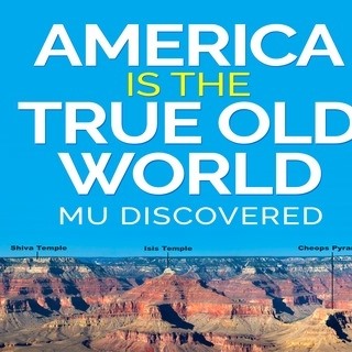
ABOUT USAmerica is the Old World is a business dedicated to Ancient American History, Ancient Civilizations, Black History, Indigenous Culture, and private remedies. This business was inspired by my new history book, “America is the True Old World, by Amunhotep Chavis El-Bey. ArchivesNo Archives Categories |
 RSS Feed
